You are here: Home > Network List > UW - Pacific Northwest Regional Seismic Network Stations List
> Station HOOD Mt Hood Meadows, OR CREST BB SMO > Earthquake Result Viewer
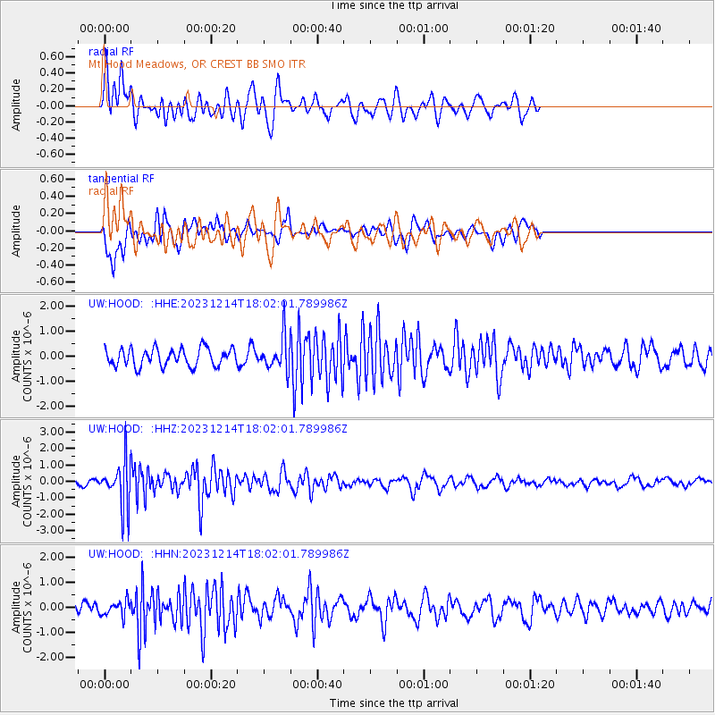
HOOD Mt Hood Meadows, OR CREST BB SMO - Earthquake Result Viewer
*The percent match for this event was below the threshold and hence no stack was calculated.
| Earthquake location: |
Near Coast Of Guatemala |
| Earthquake latitude/longitude: |
14.0/-91.4 |
| Earthquake time(UTC): |
2023/12/14 (348) 17:55:01 GMT |
| Earthquake Depth: |
78 km |
| Earthquake Magnitude: |
5.4 Mww |
| Earthquake Catalog/Contributor: |
NEIC PDE/us |
|
| Network: |
UW Pacific Northwest Regional Seismic Network |
| Station: |
HOOD Mt Hood Meadows, OR CREST BB SMO |
| Lat/Lon: |
45.32 N/121.65 W |
| Elevation: |
1520 m |
|
| Distance: |
40.4 deg |
| Az: |
326.733 deg |
| Baz: |
130.991 deg |
| Ray Param: |
$rayparam |
*The percent match for this event was below the threshold and hence was not used in the summary stack. |
|
| Radial Match: |
71.00759 % |
| Radial Bump: |
400 |
| Transverse Match: |
67.096085 % |
| Transverse Bump: |
400 |
| SOD ConfigId: |
33437571 |
| Insert Time: |
2023-12-28 18:15:59.808 +0000 |
| GWidth: |
2.5 |
| Max Bumps: |
400 |
| Tol: |
0.001 |
|
Signal To Noise
| Channel | StoN | STA | LTA |
| UW:HOOD: :HHZ:20231214T18:02:01.789986Z | 8.7867155 | 1.4013345E-6 | 1.5948332E-7 |
| UW:HOOD: :HHN:20231214T18:02:01.789986Z | 1.3831822 | 3.1339587E-7 | 2.26576E-7 |
| UW:HOOD: :HHE:20231214T18:02:01.789986Z | 1.8861023 | 6.600303E-7 | 3.4994406E-7 |
| Arrivals |
| Ps | |
| PpPs | |
| PsPs/PpSs | |


