You are here: Home > Network List > NO - Norwegian Seismic Array Network Stations List
> Station SPB1 > Earthquake Result Viewer
SPB1 - Earthquake Result Viewer
| Earthquake location: |
Philippine Islands Region |
| Earthquake latitude/longitude: |
10.4/126.1 |
| Earthquake time(UTC): |
2019/03/08 (067) 15:06:16 GMT |
| Earthquake Depth: |
54 km |
| Earthquake Magnitude: |
6.0 Mww |
| Earthquake Catalog/Contributor: |
NEIC PDE/us |
|
| Network: |
NO Norwegian Seismic Array Network |
| Station: |
SPB1 |
| Lat/Lon: |
78.18 N/16.39 E |
| Elevation: |
301 m |
|
| Distance: |
83.9 deg |
| Az: |
348.742 deg |
| Baz: |
68.693 deg |
| Ray Param: |
0.045789108 |
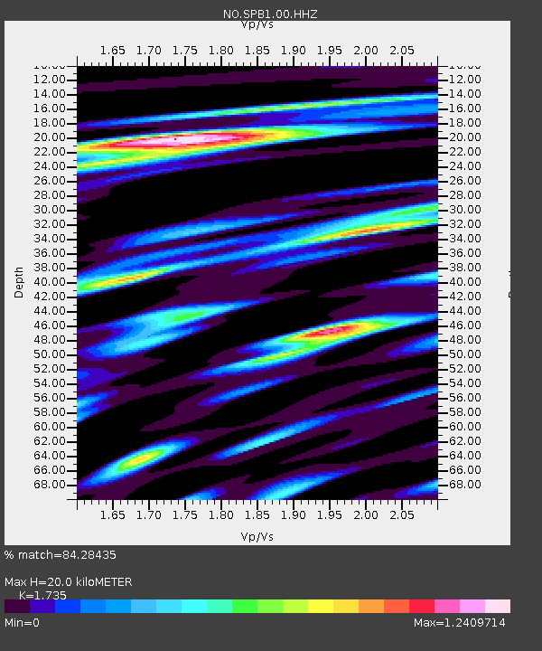
| Estimated Moho Depth: |
20.0 km |
| Estimated Crust Vp/Vs: |
1.74 |
| Assumed Crust Vp: |
6.545 km/s |
| Estimated Crust Vs: |
3.773 km/s |
| Estimated Crust Poisson's Ratio: |
0.25 |
|
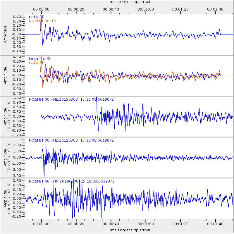
| Radial Match: |
84.28435 % |
| Radial Bump: |
400 |
| Transverse Match: |
74.07579 % |
| Transverse Bump: |
400 |
| SOD ConfigId: |
3338192 |
| Insert Time: |
2019-03-22 15:12:07.160 +0000 |
| GWidth: |
2.5 |
| Max Bumps: |
400 |
| Tol: |
0.001 |
|
Signal To Noise
| Channel | StoN | STA | LTA |
| NO:SPB1:00:HHZ:20190308T15:18:08.661987Z | 9.088014 | 9.967648E-7 | 1.0967906E-7 |
| NO:SPB1:00:HHN:20190308T15:18:08.661987Z | 3.0560992 | 2.460811E-7 | 8.05213E-8 |
| NO:SPB1:00:HHE:20190308T15:18:08.661987Z | 4.9329114 | 4.4464377E-7 | 9.01382E-8 |
| Arrivals |
| Ps | 2.3 SECOND |
| PpPs | 8.1 SECOND |
| PsPs/PpSs | 10 SECOND |


