You are here: Home > Network List > C8 - Canadian Seismic Research Network () Stations List
> Station GRIB Gribbell Island, BC, CA > Earthquake Result Viewer
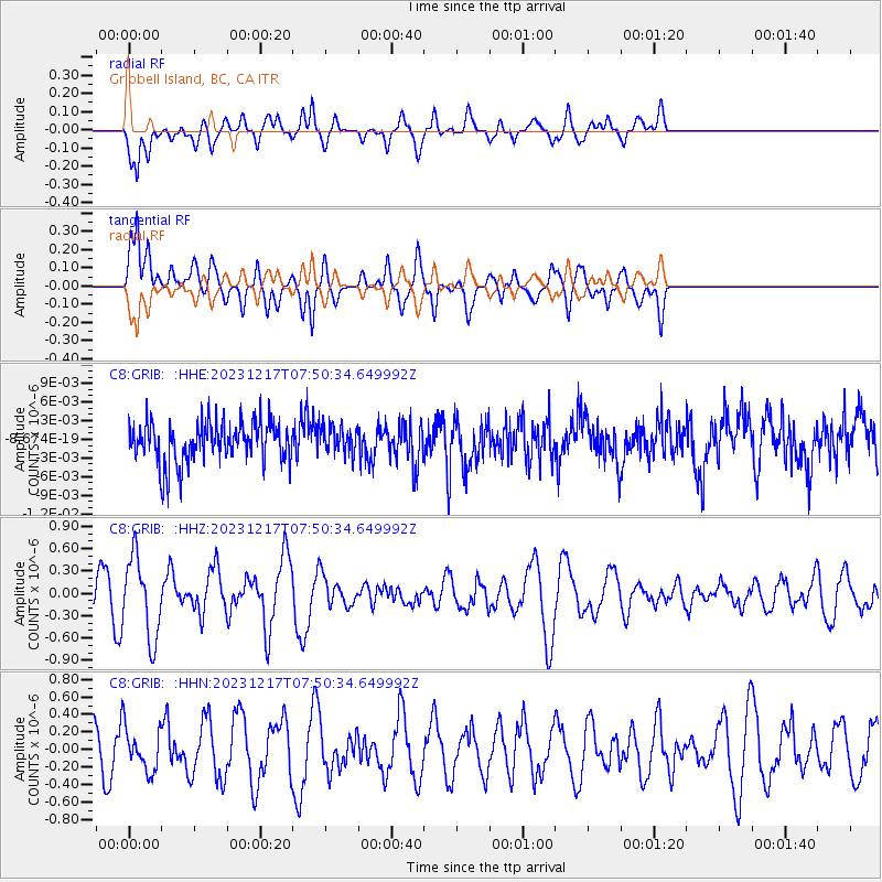
GRIB Gribbell Island, BC, CA - Earthquake Result Viewer
*The percent match for this event was below the threshold and hence no stack was calculated.
| Earthquake location: |
Southeast Of Loyalty Islands |
| Earthquake latitude/longitude: |
-21.6/169.2 |
| Earthquake time(UTC): |
2023/12/17 (351) 07:37:59 GMT |
| Earthquake Depth: |
10 km |
| Earthquake Magnitude: |
5.7 Mww |
| Earthquake Catalog/Contributor: |
NEIC PDE/us |
|
| Network: |
C8 Canadian Seismic Research Network () |
| Station: |
GRIB Gribbell Island, BC, CA |
| Lat/Lon: |
53.34 N/129.14 W |
| Elevation: |
418 m |
|
| Distance: |
91.6 deg |
| Az: |
31.882 deg |
| Baz: |
235.065 deg |
| Ray Param: |
$rayparam |
*The percent match for this event was below the threshold and hence was not used in the summary stack. |
|
| Radial Match: |
63.916325 % |
| Radial Bump: |
400 |
| Transverse Match: |
63.831448 % |
| Transverse Bump: |
400 |
| SOD ConfigId: |
33437571 |
| Insert Time: |
2023-12-31 07:45:00.603 +0000 |
| GWidth: |
2.5 |
| Max Bumps: |
400 |
| Tol: |
0.001 |
|
Signal To Noise
| Channel | StoN | STA | LTA |
| C8:GRIB: :HHZ:20231217T07:50:34.649992Z | 2.3025405 | 5.420541E-7 | 2.3541567E-7 |
| C8:GRIB: :HHN:20231217T07:50:34.649992Z | 1.0094622 | 2.514408E-7 | 2.490839E-7 |
| C8:GRIB: :HHE:20231217T07:50:34.649992Z | 0.6439845 | 2.1796642E-9 | 3.3846534E-9 |
| Arrivals |
| Ps | |
| PpPs | |
| PsPs/PpSs | |


