You are here: Home > Network List > TA - USArray Transportable Network (new EarthScope stations) Stations List
> Station V38A Canehill, AR, USA > Earthquake Result Viewer
V38A Canehill, AR, USA - Earthquake Result Viewer

| Earthquake location: |
Near East Coast Of Kamchatka |
| Earthquake latitude/longitude: |
53.6/160.1 |
| Earthquake time(UTC): |
2010/08/15 (227) 02:10:38 GMT |
| Earthquake Depth: |
40 km |
| Earthquake Magnitude: |
5.5 MB, 4.9 MS, 5.5 MW, 5.4 MW |
| Earthquake Catalog/Contributor: |
WHDF/NEIC |
|
| Network: |
TA USArray Transportable Network (new EarthScope stations) |
| Station: |
V38A Canehill, AR, USA |
| Lat/Lon: |
35.86 N/94.41 W |
| Elevation: |
372 m |
|
| Distance: |
70.2 deg |
| Az: |
56.312 deg |
| Baz: |
322.329 deg |
| Ray Param: |
0.05507319 |
| Estimated Moho Depth: |
51.5 km |
| Estimated Crust Vp/Vs: |
1.65 |
| Assumed Crust Vp: |
6.498 km/s |
| Estimated Crust Vs: |
3.944 km/s |
| Estimated Crust Poisson's Ratio: |
0.21 |
|
| Radial Match: |
80.56479 % |
| Radial Bump: |
400 |
| Transverse Match: |
64.92007 % |
| Transverse Bump: |
400 |
| SOD ConfigId: |
319893 |
| Insert Time: |
2011-01-05 23:43:12.428 +0000 |
| GWidth: |
2.5 |
| Max Bumps: |
400 |
| Tol: |
0.001 |
|
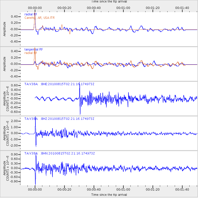
Signal To Noise
| Channel | StoN | STA | LTA |
| TA:V38A: :BHZ:20100815T02:21:16.174973Z | 14.710888 | 7.125689E-7 | 4.8438196E-8 |
| TA:V38A: :BHN:20100815T02:21:16.174973Z | 8.169287 | 3.2393135E-7 | 3.9652342E-8 |
| TA:V38A: :BHE:20100815T02:21:16.174973Z | 4.916137 | 2.2017089E-7 | 4.478534E-8 |
| Arrivals |
| Ps | 5.3 SECOND |
| PpPs | 20 SECOND |
| PsPs/PpSs | 25 SECOND |


