You are here: Home > Network List > G - GEOSCOPE Stations List
> Station INU Inuyama, Japan > Earthquake Result Viewer
INU Inuyama, Japan - Earthquake Result Viewer
*The percent match for this event was below the threshold and hence no stack was calculated.
| Earthquake location: |
Southeast Of Loyalty Islands |
| Earthquake latitude/longitude: |
-21.6/169.2 |
| Earthquake time(UTC): |
2023/12/17 (351) 07:37:59 GMT |
| Earthquake Depth: |
10 km |
| Earthquake Magnitude: |
5.7 Mww |
| Earthquake Catalog/Contributor: |
NEIC PDE/us |
|
| Network: |
G GEOSCOPE |
| Station: |
INU Inuyama, Japan |
| Lat/Lon: |
35.35 N/137.03 E |
| Elevation: |
132 m |
|
| Distance: |
64.3 deg |
| Az: |
331.143 deg |
| Baz: |
146.665 deg |
| Ray Param: |
$rayparam |
*The percent match for this event was below the threshold and hence was not used in the summary stack. |
|
| Radial Match: |
56.119637 % |
| Radial Bump: |
400 |
| Transverse Match: |
51.176105 % |
| Transverse Bump: |
395 |
| SOD ConfigId: |
33437571 |
| Insert Time: |
2023-12-31 07:48:03.614 +0000 |
| GWidth: |
2.5 |
| Max Bumps: |
400 |
| Tol: |
0.001 |
|
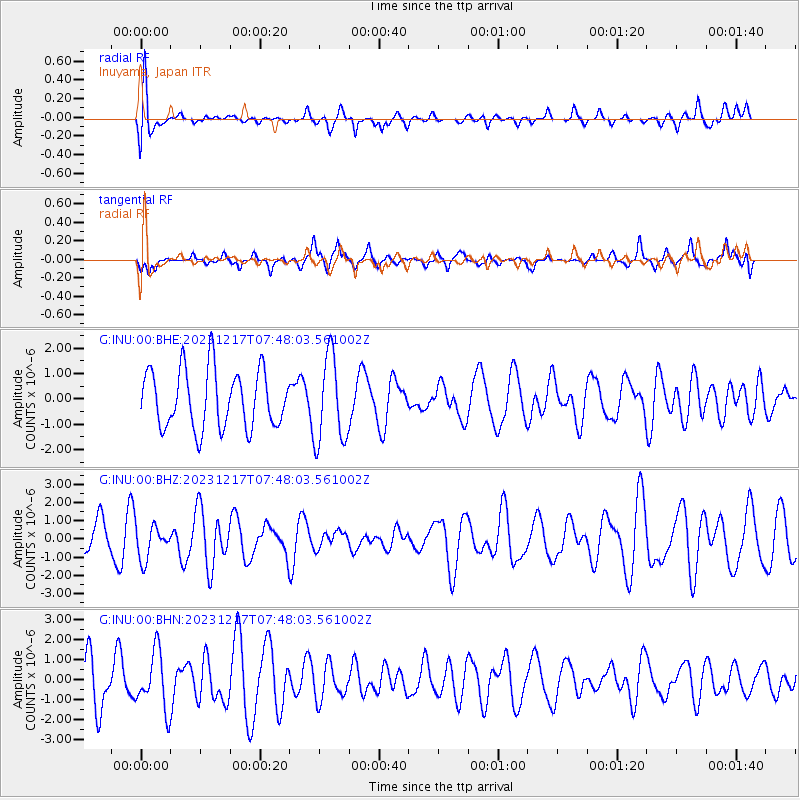
Signal To Noise
| Channel | StoN | STA | LTA |
| G:INU:00:BHZ:20231217T07:48:03.561002Z | 0.7802494 | 9.0702855E-7 | 1.1624854E-6 |
| G:INU:00:BHN:20231217T07:48:03.561002Z | 1.4989165 | 1.4413266E-6 | 9.615791E-7 |
| G:INU:00:BHE:20231217T07:48:03.561002Z | 1.4929719 | 1.7136118E-6 | 1.1477857E-6 |
| Arrivals |
| Ps | |
| PpPs | |
| PsPs/PpSs | |


