You are here: Home > Network List > US - United States National Seismic Network Stations List
> Station MNTX Cornudas Mountains, Texas, USA > Earthquake Result Viewer
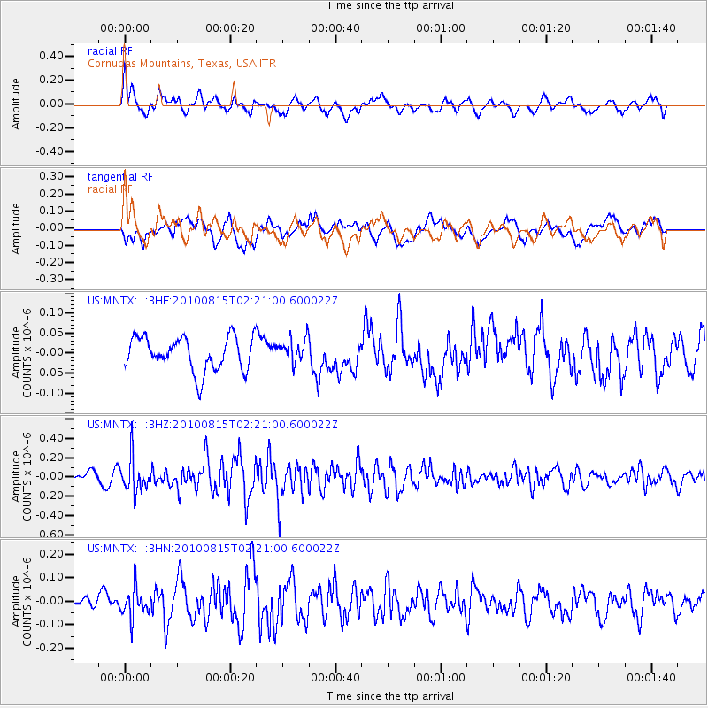
MNTX Cornudas Mountains, Texas, USA - Earthquake Result Viewer
*The percent match for this event was below the threshold and hence no stack was calculated.
| Earthquake location: |
Near East Coast Of Kamchatka |
| Earthquake latitude/longitude: |
53.6/160.1 |
| Earthquake time(UTC): |
2010/08/15 (227) 02:10:38 GMT |
| Earthquake Depth: |
40 km |
| Earthquake Magnitude: |
5.5 MB, 4.9 MS, 5.5 MW, 5.4 MW |
| Earthquake Catalog/Contributor: |
WHDF/NEIC |
|
| Network: |
US United States National Seismic Network |
| Station: |
MNTX Cornudas Mountains, Texas, USA |
| Lat/Lon: |
31.70 N/105.38 W |
| Elevation: |
404 m |
|
| Distance: |
67.7 deg |
| Az: |
66.721 deg |
| Baz: |
319.989 deg |
| Ray Param: |
$rayparam |
*The percent match for this event was below the threshold and hence was not used in the summary stack. |
|
| Radial Match: |
67.72848 % |
| Radial Bump: |
400 |
| Transverse Match: |
60.096813 % |
| Transverse Bump: |
400 |
| SOD ConfigId: |
319893 |
| Insert Time: |
2011-01-05 23:48:26.173 +0000 |
| GWidth: |
2.5 |
| Max Bumps: |
400 |
| Tol: |
0.001 |
|
Signal To Noise
| Channel | StoN | STA | LTA |
| US:MNTX: :BHZ:20100815T02:21:00.600022Z | 2.6705759 | 1.7657311E-7 | 6.611799E-8 |
| US:MNTX: :BHN:20100815T02:21:00.600022Z | 2.0058653 | 6.105766E-8 | 3.0439562E-8 |
| US:MNTX: :BHE:20100815T02:21:00.600022Z | 0.71585405 | 2.9699713E-8 | 4.1488505E-8 |
| Arrivals |
| Ps | |
| PpPs | |
| PsPs/PpSs | |


