You are here: Home > Network List > US - United States National Seismic Network Stations List
> Station EGMT Eagleton, Montana, USA > Earthquake Result Viewer
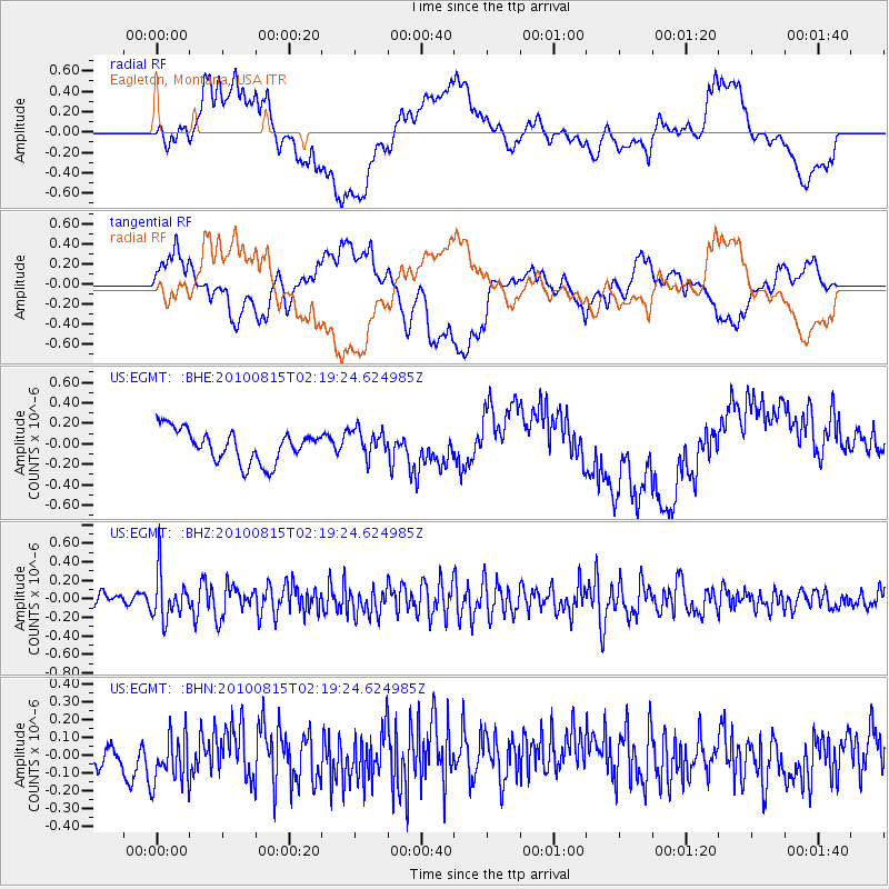
EGMT Eagleton, Montana, USA - Earthquake Result Viewer
*The percent match for this event was below the threshold and hence no stack was calculated.
| Earthquake location: |
Near East Coast Of Kamchatka |
| Earthquake latitude/longitude: |
53.6/160.1 |
| Earthquake time(UTC): |
2010/08/15 (227) 02:10:38 GMT |
| Earthquake Depth: |
40 km |
| Earthquake Magnitude: |
5.5 MB, 4.9 MS, 5.5 MW, 5.4 MW |
| Earthquake Catalog/Contributor: |
WHDF/NEIC |
|
| Network: |
US United States National Seismic Network |
| Station: |
EGMT Eagleton, Montana, USA |
| Lat/Lon: |
48.02 N/109.75 W |
| Elevation: |
1055 m |
|
| Distance: |
53.6 deg |
| Az: |
56.557 deg |
| Baz: |
312.133 deg |
| Ray Param: |
$rayparam |
*The percent match for this event was below the threshold and hence was not used in the summary stack. |
|
| Radial Match: |
38.1491 % |
| Radial Bump: |
400 |
| Transverse Match: |
35.945354 % |
| Transverse Bump: |
400 |
| SOD ConfigId: |
319893 |
| Insert Time: |
2011-01-05 23:49:04.074 +0000 |
| GWidth: |
2.5 |
| Max Bumps: |
400 |
| Tol: |
0.001 |
|
Signal To Noise
| Channel | StoN | STA | LTA |
| US:EGMT: :BHZ:20100815T02:19:24.624985Z | 3.7137642 | 2.5118555E-7 | 6.763638E-8 |
| US:EGMT: :BHN:20100815T02:19:24.624985Z | 0.9841581 | 1.7426603E-7 | 1.7707119E-7 |
| US:EGMT: :BHE:20100815T02:19:24.624985Z | 0.84867316 | 1.3353045E-7 | 1.5734027E-7 |
| Arrivals |
| Ps | |
| PpPs | |
| PsPs/PpSs | |


