You are here: Home > Network List > N4 - Central and EAstern US Network Stations List
> Station Y60A Bolivia, NC, USA > Earthquake Result Viewer
Y60A Bolivia, NC, USA - Earthquake Result Viewer
| Earthquake location: |
Southern Peru |
| Earthquake latitude/longitude: |
-16.0/-72.6 |
| Earthquake time(UTC): |
2023/12/20 (354) 12:11:20 GMT |
| Earthquake Depth: |
93 km |
| Earthquake Magnitude: |
6.2 mww |
| Earthquake Catalog/Contributor: |
NEIC PDE/us |
|
| Network: |
N4 Central and EAstern US Network |
| Station: |
Y60A Bolivia, NC, USA |
| Lat/Lon: |
34.00 N/78.22 W |
| Elevation: |
7.0 m |
|
| Distance: |
50.0 deg |
| Az: |
353.908 deg |
| Baz: |
172.942 deg |
| Ray Param: |
0.068063185 |
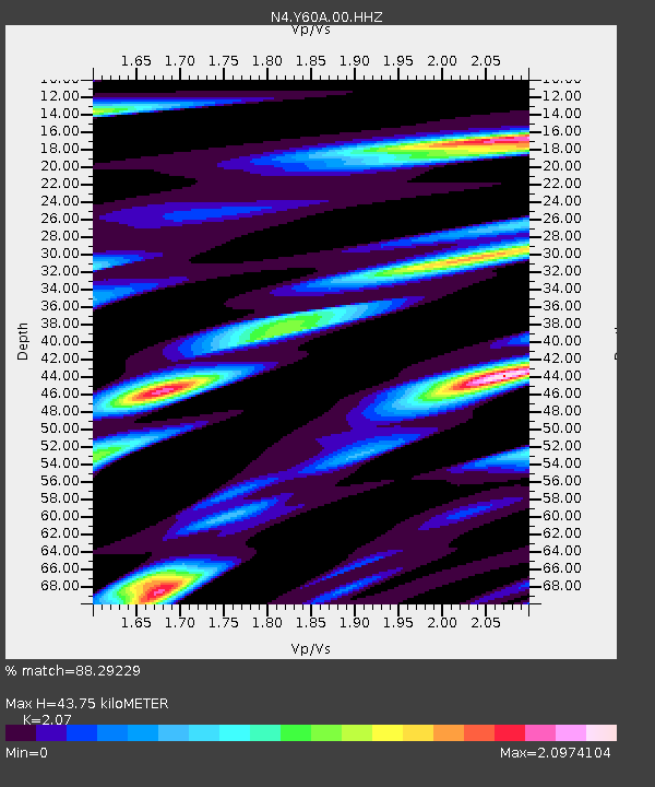
| Estimated Moho Depth: |
43.75 km |
| Estimated Crust Vp/Vs: |
2.07 |
| Assumed Crust Vp: |
6.565 km/s |
| Estimated Crust Vs: |
3.171 km/s |
| Estimated Crust Poisson's Ratio: |
0.35 |
|
| Radial Match: |
88.29229 % |
| Radial Bump: |
370 |
| Transverse Match: |
62.70459 % |
| Transverse Bump: |
400 |
| SOD ConfigId: |
33437571 |
| Insert Time: |
2024-01-03 12:28:20.595 +0000 |
| GWidth: |
2.5 |
| Max Bumps: |
400 |
| Tol: |
0.001 |
|

Signal To Noise
| Channel | StoN | STA | LTA |
| N4:Y60A:00:HHZ:20231220T12:19:35.04999Z | 2.2613363 | 1.0335306E-6 | 4.5704414E-7 |
| N4:Y60A:00:HH1:20231220T12:19:35.04999Z | 1.3185958 | 7.9969095E-7 | 6.0647164E-7 |
| N4:Y60A:00:HH2:20231220T12:19:35.04999Z | 0.56261134 | 3.448171E-7 | 6.128868E-7 |
| Arrivals |
| Ps | 7.5 SECOND |
| PpPs | 19 SECOND |
| PsPs/PpSs | 27 SECOND |


