You are here: Home > Network List > NE - New England Seismic Network Stations List
> Station EMMW Machias, ME, USA > Earthquake Result Viewer
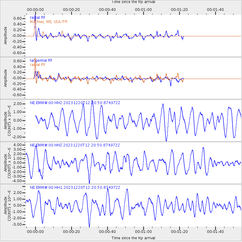
EMMW Machias, ME, USA - Earthquake Result Viewer
*The percent match for this event was below the threshold and hence no stack was calculated.
| Earthquake location: |
Southern Peru |
| Earthquake latitude/longitude: |
-16.0/-72.6 |
| Earthquake time(UTC): |
2023/12/20 (354) 12:11:20 GMT |
| Earthquake Depth: |
93 km |
| Earthquake Magnitude: |
6.2 mww |
| Earthquake Catalog/Contributor: |
NEIC PDE/us |
|
| Network: |
NE New England Seismic Network |
| Station: |
EMMW Machias, ME, USA |
| Lat/Lon: |
44.71 N/67.46 W |
| Elevation: |
35 m |
|
| Distance: |
60.6 deg |
| Az: |
4.211 deg |
| Baz: |
185.686 deg |
| Ray Param: |
$rayparam |
*The percent match for this event was below the threshold and hence was not used in the summary stack. |
|
| Radial Match: |
65.68057 % |
| Radial Bump: |
400 |
| Transverse Match: |
80.17265 % |
| Transverse Bump: |
273 |
| SOD ConfigId: |
33437571 |
| Insert Time: |
2024-01-03 12:28:36.980 +0000 |
| GWidth: |
2.5 |
| Max Bumps: |
400 |
| Tol: |
0.001 |
|
Signal To Noise
| Channel | StoN | STA | LTA |
| NE:EMMW:00:HHZ:20231220T12:20:50.874972Z | 1.706472 | 2.3651612E-6 | 1.3859946E-6 |
| NE:EMMW:00:HH1:20231220T12:20:50.874972Z | 1.2579266 | 1.622085E-6 | 1.2894909E-6 |
| NE:EMMW:00:HH2:20231220T12:20:50.874972Z | 1.9787328 | 1.5151081E-6 | 7.6569614E-7 |
| Arrivals |
| Ps | |
| PpPs | |
| PsPs/PpSs | |


