You are here: Home > Network List > IW - Intermountain West Stations List
> Station MOOW Moose Ponds, Wyoming, USA > Earthquake Result Viewer
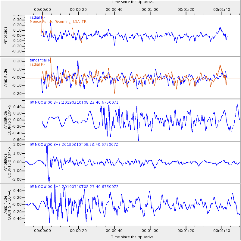
MOOW Moose Ponds, Wyoming, USA - Earthquake Result Viewer
*The percent match for this event was below the threshold and hence no stack was calculated.
| Earthquake location: |
Fiji Islands Region |
| Earthquake latitude/longitude: |
-17.8/-178.7 |
| Earthquake time(UTC): |
2019/03/10 (069) 08:12:25 GMT |
| Earthquake Depth: |
567 km |
| Earthquake Magnitude: |
6.2 Mww |
| Earthquake Catalog/Contributor: |
NEIC PDE/us |
|
| Network: |
IW Intermountain West |
| Station: |
MOOW Moose Ponds, Wyoming, USA |
| Lat/Lon: |
43.75 N/110.74 W |
| Elevation: |
2128 m |
|
| Distance: |
87.1 deg |
| Az: |
42.25 deg |
| Baz: |
242.101 deg |
| Ray Param: |
$rayparam |
*The percent match for this event was below the threshold and hence was not used in the summary stack. |
|
| Radial Match: |
74.41711 % |
| Radial Bump: |
400 |
| Transverse Match: |
73.93522 % |
| Transverse Bump: |
400 |
| SOD ConfigId: |
3338192 |
| Insert Time: |
2019-03-24 08:30:48.655 +0000 |
| GWidth: |
2.5 |
| Max Bumps: |
400 |
| Tol: |
0.001 |
|
Signal To Noise
| Channel | StoN | STA | LTA |
| IW:MOOW:00:BHZ:20190310T08:23:40.675007Z | 6.4751334 | 1.0606872E-6 | 1.6380932E-7 |
| IW:MOOW:00:BH1:20190310T08:23:40.675007Z | 2.7512174 | 1.8409688E-7 | 6.6914694E-8 |
| IW:MOOW:00:BH2:20190310T08:23:40.675007Z | 2.5894315 | 2.5229357E-7 | 9.7432036E-8 |
| Arrivals |
| Ps | |
| PpPs | |
| PsPs/PpSs | |


