You are here: Home > Network List > TX - Texas Seismological Network Stations List
> Station HNDO Hondo > Earthquake Result Viewer
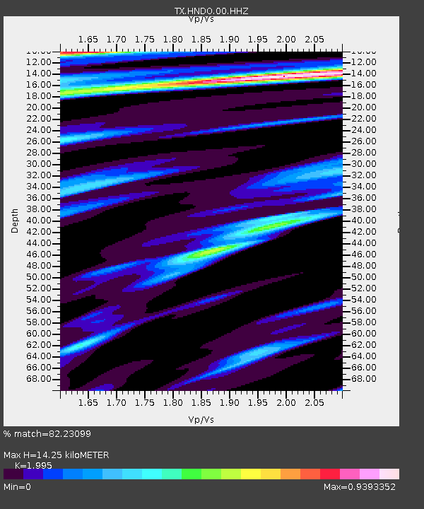
HNDO Hondo - Earthquake Result Viewer
| Earthquake location: |
Southern Peru |
| Earthquake latitude/longitude: |
-16.0/-72.6 |
| Earthquake time(UTC): |
2023/12/20 (354) 12:11:20 GMT |
| Earthquake Depth: |
93 km |
| Earthquake Magnitude: |
6.2 mww |
| Earthquake Catalog/Contributor: |
NEIC PDE/us |
|
| Network: |
TX Texas Seismological Network |
| Station: |
HNDO Hondo |
| Lat/Lon: |
29.53 N/99.28 W |
| Elevation: |
381 m |
|
| Distance: |
52.0 deg |
| Az: |
330.245 deg |
| Baz: |
146.785 deg |
| Ray Param: |
0.06671686 |
| Estimated Moho Depth: |
14.25 km |
| Estimated Crust Vp/Vs: |
2.00 |
| Assumed Crust Vp: |
6.347 km/s |
| Estimated Crust Vs: |
3.181 km/s |
| Estimated Crust Poisson's Ratio: |
0.33 |
|
| Radial Match: |
82.23099 % |
| Radial Bump: |
363 |
| Transverse Match: |
71.74834 % |
| Transverse Bump: |
400 |
| SOD ConfigId: |
33437571 |
| Insert Time: |
2024-01-03 12:33:36.259 +0000 |
| GWidth: |
2.5 |
| Max Bumps: |
400 |
| Tol: |
0.001 |
|

Signal To Noise
| Channel | StoN | STA | LTA |
| TX:HNDO:00:HHZ:20231220T12:19:50.500003Z | 4.433452 | 7.48474E-7 | 1.688242E-7 |
| TX:HNDO:00:HH1:20231220T12:19:50.500003Z | 1.5154246 | 1.7376605E-7 | 1.14664935E-7 |
| TX:HNDO:00:HH2:20231220T12:19:50.500003Z | 1.8460547 | 3.3438408E-7 | 1.8113445E-7 |
| Arrivals |
| Ps | 2.3 SECOND |
| PpPs | 6.4 SECOND |
| PsPs/PpSs | 8.8 SECOND |


