You are here: Home > Network List > CI - Caltech Regional Seismic Network Stations List
> Station SMM Simmler, CA, USA > Earthquake Result Viewer
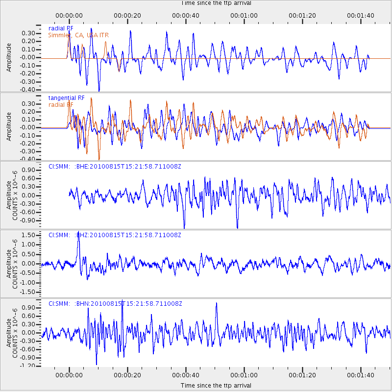
SMM Simmler, CA, USA - Earthquake Result Viewer
*The percent match for this event was below the threshold and hence no stack was calculated.
| Earthquake location: |
New Britain Region, P.N.G. |
| Earthquake latitude/longitude: |
-5.7/148.3 |
| Earthquake time(UTC): |
2010/08/15 (227) 15:09:29 GMT |
| Earthquake Depth: |
175 km |
| Earthquake Magnitude: |
5.8 MB, 6.3 MW, 6.3 MW |
| Earthquake Catalog/Contributor: |
WHDF/NEIC |
|
| Network: |
CI Caltech Regional Seismic Network |
| Station: |
SMM Simmler, CA, USA |
| Lat/Lon: |
35.31 N/120.00 W |
| Elevation: |
599 m |
|
| Distance: |
94.6 deg |
| Az: |
55.097 deg |
| Baz: |
266.321 deg |
| Ray Param: |
$rayparam |
*The percent match for this event was below the threshold and hence was not used in the summary stack. |
|
| Radial Match: |
57.442654 % |
| Radial Bump: |
400 |
| Transverse Match: |
59.2347 % |
| Transverse Bump: |
400 |
| SOD ConfigId: |
319893 |
| Insert Time: |
2011-01-05 23:58:18.822 +0000 |
| GWidth: |
2.5 |
| Max Bumps: |
400 |
| Tol: |
0.001 |
|
Signal To Noise
| Channel | StoN | STA | LTA |
| CI:SMM: :BHZ:20100815T15:21:58.711008Z | 6.0463266 | 5.4937016E-7 | 9.086015E-8 |
| CI:SMM: :BHN:20100815T15:21:58.711008Z | 1.098597 | 1.642065E-7 | 1.4946927E-7 |
| CI:SMM: :BHE:20100815T15:21:58.711008Z | 1.5153955 | 2.1513061E-7 | 1.4196334E-7 |
| Arrivals |
| Ps | |
| PpPs | |
| PsPs/PpSs | |


