You are here: Home > Network List > G - GEOSCOPE Stations List
> Station INU Inuyama, Japan > Earthquake Result Viewer
INU Inuyama, Japan - Earthquake Result Viewer

| Earthquake location: |
New Britain Region, P.N.G. |
| Earthquake latitude/longitude: |
-5.7/148.3 |
| Earthquake time(UTC): |
2010/08/15 (227) 15:09:29 GMT |
| Earthquake Depth: |
175 km |
| Earthquake Magnitude: |
5.8 MB, 6.3 MW, 6.3 MW |
| Earthquake Catalog/Contributor: |
WHDF/NEIC |
|
| Network: |
G GEOSCOPE |
| Station: |
INU Inuyama, Japan |
| Lat/Lon: |
35.35 N/137.03 E |
| Elevation: |
132 m |
|
| Distance: |
42.2 deg |
| Az: |
346.185 deg |
| Baz: |
163.101 deg |
| Ray Param: |
0.07267027 |
| Estimated Moho Depth: |
26.5 km |
| Estimated Crust Vp/Vs: |
1.79 |
| Assumed Crust Vp: |
6.461 km/s |
| Estimated Crust Vs: |
3.615 km/s |
| Estimated Crust Poisson's Ratio: |
0.27 |
|
| Radial Match: |
93.48562 % |
| Radial Bump: |
400 |
| Transverse Match: |
79.407295 % |
| Transverse Bump: |
400 |
| SOD ConfigId: |
319893 |
| Insert Time: |
2011-01-05 23:59:43.743 +0000 |
| GWidth: |
2.5 |
| Max Bumps: |
400 |
| Tol: |
0.001 |
|
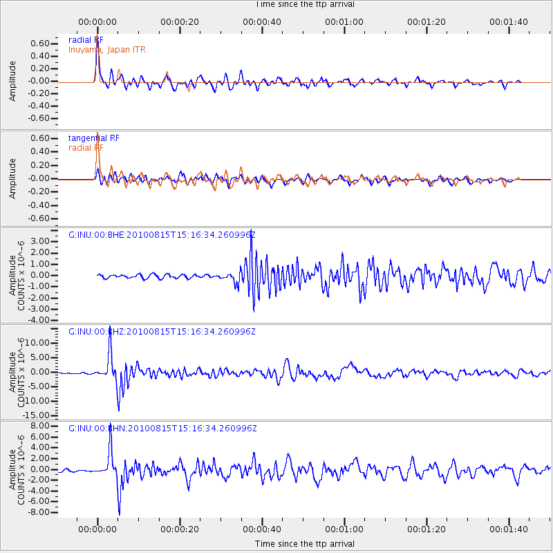
Signal To Noise
| Channel | StoN | STA | LTA |
| G:INU:00:BHZ:20100815T15:16:34.260996Z | 25.01658 | 4.8773827E-6 | 1.9496599E-7 |
| G:INU:00:BHN:20100815T15:16:34.260996Z | 14.119864 | 2.6005102E-6 | 1.8417389E-7 |
| G:INU:00:BHE:20100815T15:16:34.260996Z | 2.84289 | 4.5046252E-7 | 1.5845232E-7 |
| Arrivals |
| Ps | 3.5 SECOND |
| PpPs | 11 SECOND |
| PsPs/PpSs | 14 SECOND |


