You are here: Home > Network List > GO - National Seismic Network of Georgia Stations List
> Station MINA Georgia, Mina > Earthquake Result Viewer
MINA Georgia, Mina - Earthquake Result Viewer
| Earthquake location: |
Andreanof Islands, Aleutian Is. |
| Earthquake latitude/longitude: |
51.3/-175.4 |
| Earthquake time(UTC): |
2023/12/21 (355) 14:55:58 GMT |
| Earthquake Depth: |
30 km |
| Earthquake Magnitude: |
6.1 Mww |
| Earthquake Catalog/Contributor: |
NEIC PDE/us |
|
| Network: |
GO National Seismic Network of Georgia |
| Station: |
MINA Georgia, Mina |
| Lat/Lon: |
41.60 N/43.02 E |
| Elevation: |
1568 m |
|
| Distance: |
81.6 deg |
| Az: |
331.922 deg |
| Baz: |
23.187 deg |
| Ray Param: |
0.04743807 |
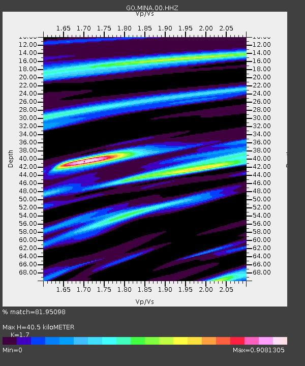
| Estimated Moho Depth: |
40.5 km |
| Estimated Crust Vp/Vs: |
1.70 |
| Assumed Crust Vp: |
6.419 km/s |
| Estimated Crust Vs: |
3.776 km/s |
| Estimated Crust Poisson's Ratio: |
0.24 |
|
| Radial Match: |
81.95098 % |
| Radial Bump: |
400 |
| Transverse Match: |
58.978943 % |
| Transverse Bump: |
400 |
| SOD ConfigId: |
33437571 |
| Insert Time: |
2024-01-04 15:08:13.427 +0000 |
| GWidth: |
2.5 |
| Max Bumps: |
400 |
| Tol: |
0.001 |
|

Signal To Noise
| Channel | StoN | STA | LTA |
| GO:MINA:00:HHZ:20231221T15:07:42.029986Z | 3.7795682 | 4.4352998E-7 | 1.1734938E-7 |
| GO:MINA:00:HHN:20231221T15:07:42.029986Z | 1.8023748 | 1.7711565E-7 | 9.826794E-8 |
| GO:MINA:00:HHE:20231221T15:07:42.029986Z | 0.895176 | 9.881709E-8 | 1.1038845E-7 |
| Arrivals |
| Ps | 4.5 SECOND |
| PpPs | 17 SECOND |
| PsPs/PpSs | 21 SECOND |


