You are here: Home > Network List > KR - Kyrgyz Digital Network Stations List
> Station SALK Salom-Alik, Kyrgyzstan > Earthquake Result Viewer
SALK Salom-Alik, Kyrgyzstan - Earthquake Result Viewer
| Earthquake location: |
Andreanof Islands, Aleutian Is. |
| Earthquake latitude/longitude: |
51.3/-175.4 |
| Earthquake time(UTC): |
2023/12/21 (355) 14:55:58 GMT |
| Earthquake Depth: |
30 km |
| Earthquake Magnitude: |
6.1 Mww |
| Earthquake Catalog/Contributor: |
NEIC PDE/us |
|
| Network: |
KR Kyrgyz Digital Network |
| Station: |
SALK Salom-Alik, Kyrgyzstan |
| Lat/Lon: |
40.88 N/73.82 E |
| Elevation: |
1672 m |
|
| Distance: |
70.2 deg |
| Az: |
311.134 deg |
| Baz: |
38.555 deg |
| Ray Param: |
0.05510785 |
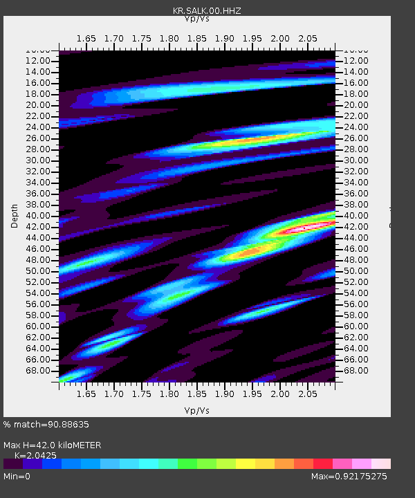
| Estimated Moho Depth: |
42.0 km |
| Estimated Crust Vp/Vs: |
2.04 |
| Assumed Crust Vp: |
6.306 km/s |
| Estimated Crust Vs: |
3.087 km/s |
| Estimated Crust Poisson's Ratio: |
0.34 |
|
| Radial Match: |
90.88635 % |
| Radial Bump: |
400 |
| Transverse Match: |
86.35762 % |
| Transverse Bump: |
400 |
| SOD ConfigId: |
33437571 |
| Insert Time: |
2024-01-04 15:11:23.184 +0000 |
| GWidth: |
2.5 |
| Max Bumps: |
400 |
| Tol: |
0.001 |
|

Signal To Noise
| Channel | StoN | STA | LTA |
| KR:SALK:00:HHZ:20231221T15:06:37.269977Z | 9.516359 | 8.421316E-7 | 8.8493046E-8 |
| KR:SALK:00:HHN:20231221T15:06:37.269977Z | 3.6750698 | 3.1054884E-7 | 8.450148E-8 |
| KR:SALK:00:HHE:20231221T15:06:37.269977Z | 3.7436426 | 3.473683E-7 | 9.278885E-8 |
| Arrivals |
| Ps | 7.2 SECOND |
| PpPs | 20 SECOND |
| PsPs/PpSs | 27 SECOND |


