You are here: Home > Network List > NE - New England Seismic Network Stations List
> Station VT1 Waterbury, VT, USA > Earthquake Result Viewer
VT1 Waterbury, VT, USA - Earthquake Result Viewer
| Earthquake location: |
Southern East Pacific Rise |
| Earthquake latitude/longitude: |
-24.0/-115.4 |
| Earthquake time(UTC): |
2023/12/10 (344) 13:29:28 GMT |
| Earthquake Depth: |
10 km |
| Earthquake Magnitude: |
5.5 Mww |
| Earthquake Catalog/Contributor: |
NEIC PDE/us |
|
| Network: |
NE New England Seismic Network |
| Station: |
VT1 Waterbury, VT, USA |
| Lat/Lon: |
44.32 N/72.75 W |
| Elevation: |
149 m |
|
| Distance: |
78.4 deg |
| Az: |
29.756 deg |
| Baz: |
219.222 deg |
| Ray Param: |
0.049679365 |
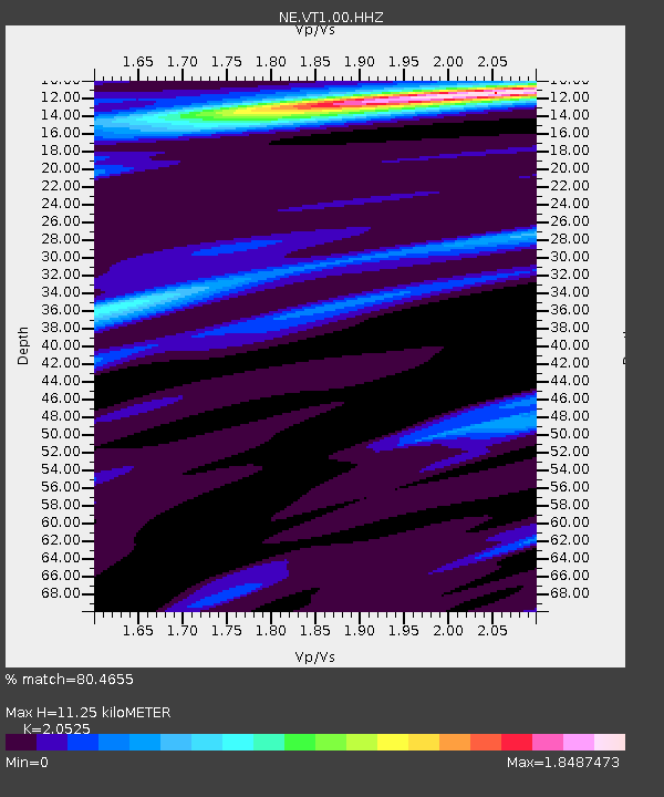
| Estimated Moho Depth: |
11.25 km |
| Estimated Crust Vp/Vs: |
2.05 |
| Assumed Crust Vp: |
6.419 km/s |
| Estimated Crust Vs: |
3.128 km/s |
| Estimated Crust Poisson's Ratio: |
0.34 |
|
| Radial Match: |
80.4655 % |
| Radial Bump: |
400 |
| Transverse Match: |
69.17011 % |
| Transverse Bump: |
400 |
| SOD ConfigId: |
33437571 |
| Insert Time: |
2024-01-04 15:47:02.792 +0000 |
| GWidth: |
2.5 |
| Max Bumps: |
400 |
| Tol: |
0.001 |
|

Signal To Noise
| Channel | StoN | STA | LTA |
| NE:VT1:00:HHZ:20231210T13:40:57.284023Z | 1.4751949 | 6.930237E-7 | 4.697845E-7 |
| NE:VT1:00:HH1:20231210T13:40:57.284023Z | 1.4200151 | 4.8273296E-7 | 3.3994917E-7 |
| NE:VT1:00:HH2:20231210T13:40:57.284023Z | 1.4346716 | 4.999373E-7 | 3.484681E-7 |
| Arrivals |
| Ps | 1.9 SECOND |
| PpPs | 5.2 SECOND |
| PsPs/PpSs | 7.1 SECOND |


