You are here: Home > Network List > TX - Texas Seismological Network Stations List
> Station WTFS Witchita Falls > Earthquake Result Viewer
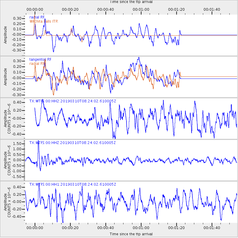
WTFS Witchita Falls - Earthquake Result Viewer
*The percent match for this event was below the threshold and hence no stack was calculated.
| Earthquake location: |
Fiji Islands Region |
| Earthquake latitude/longitude: |
-17.8/-178.7 |
| Earthquake time(UTC): |
2019/03/10 (069) 08:12:25 GMT |
| Earthquake Depth: |
567 km |
| Earthquake Magnitude: |
6.2 Mww |
| Earthquake Catalog/Contributor: |
NEIC PDE/us |
|
| Network: |
TX Texas Seismological Network |
| Station: |
WTFS Witchita Falls |
| Lat/Lon: |
33.77 N/98.46 W |
| Elevation: |
277 m |
|
| Distance: |
91.9 deg |
| Az: |
55.218 deg |
| Baz: |
249.913 deg |
| Ray Param: |
$rayparam |
*The percent match for this event was below the threshold and hence was not used in the summary stack. |
|
| Radial Match: |
48.065323 % |
| Radial Bump: |
400 |
| Transverse Match: |
57.429295 % |
| Transverse Bump: |
400 |
| SOD ConfigId: |
3338192 |
| Insert Time: |
2019-03-24 08:32:40.516 +0000 |
| GWidth: |
2.5 |
| Max Bumps: |
400 |
| Tol: |
0.001 |
|
Signal To Noise
| Channel | StoN | STA | LTA |
| TX:WTFS:00:HHZ:20190310T08:24:02.610005Z | 4.2362323 | 6.2388557E-7 | 1.4727368E-7 |
| TX:WTFS:00:HH1:20190310T08:24:02.610005Z | 1.3848628 | 1.9579693E-7 | 1.4138362E-7 |
| TX:WTFS:00:HH2:20190310T08:24:02.610005Z | 0.82359636 | 1.2355167E-7 | 1.5001484E-7 |
| Arrivals |
| Ps | |
| PpPs | |
| PsPs/PpSs | |


