You are here: Home > Network List > UW - Pacific Northwest Regional Seismic Network Stations List
> Station MRBL Marblemount, WA, USA > Earthquake Result Viewer
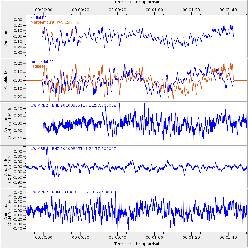
MRBL Marblemount, WA, USA - Earthquake Result Viewer
*The percent match for this event was below the threshold and hence no stack was calculated.
| Earthquake location: |
New Britain Region, P.N.G. |
| Earthquake latitude/longitude: |
-5.7/148.3 |
| Earthquake time(UTC): |
2010/08/15 (227) 15:09:29 GMT |
| Earthquake Depth: |
175 km |
| Earthquake Magnitude: |
5.8 MB, 6.3 MW, 6.3 MW |
| Earthquake Catalog/Contributor: |
WHDF/NEIC |
|
| Network: |
UW Pacific Northwest Regional Seismic Network |
| Station: |
MRBL Marblemount, WA, USA |
| Lat/Lon: |
48.52 N/121.48 W |
| Elevation: |
75 m |
|
| Distance: |
94.3 deg |
| Az: |
41.819 deg |
| Baz: |
266.363 deg |
| Ray Param: |
$rayparam |
*The percent match for this event was below the threshold and hence was not used in the summary stack. |
|
| Radial Match: |
54.382256 % |
| Radial Bump: |
400 |
| Transverse Match: |
70.19202 % |
| Transverse Bump: |
400 |
| SOD ConfigId: |
319893 |
| Insert Time: |
2011-01-06 00:06:38.883 +0000 |
| GWidth: |
2.5 |
| Max Bumps: |
400 |
| Tol: |
0.001 |
|
Signal To Noise
| Channel | StoN | STA | LTA |
| UW:MRBL: :BHZ:20100815T15:21:57.50001Z | 7.217709 | 4.466801E-7 | 6.188669E-8 |
| UW:MRBL: :BHN:20100815T15:21:57.50001Z | 1.3559122 | 1.15396304E-7 | 8.510603E-8 |
| UW:MRBL: :BHE:20100815T15:21:57.50001Z | 1.989968 | 1.8070449E-7 | 9.080774E-8 |
| Arrivals |
| Ps | |
| PpPs | |
| PsPs/PpSs | |


