You are here: Home > Network List > UW - Pacific Northwest Regional Seismic Network Stations List
> Station LEBA Lebam, WA, USA > Earthquake Result Viewer
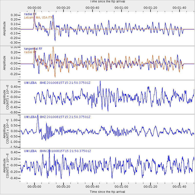
LEBA Lebam, WA, USA - Earthquake Result Viewer
*The percent match for this event was below the threshold and hence no stack was calculated.
| Earthquake location: |
New Britain Region, P.N.G. |
| Earthquake latitude/longitude: |
-5.7/148.3 |
| Earthquake time(UTC): |
2010/08/15 (227) 15:09:29 GMT |
| Earthquake Depth: |
175 km |
| Earthquake Magnitude: |
5.8 MB, 6.3 MW, 6.3 MW |
| Earthquake Catalog/Contributor: |
WHDF/NEIC |
|
| Network: |
UW Pacific Northwest Regional Seismic Network |
| Station: |
LEBA Lebam, WA, USA |
| Lat/Lon: |
46.55 N/123.56 W |
| Elevation: |
73 m |
|
| Distance: |
92.8 deg |
| Az: |
43.68 deg |
| Baz: |
264.718 deg |
| Ray Param: |
$rayparam |
*The percent match for this event was below the threshold and hence was not used in the summary stack. |
|
| Radial Match: |
69.46086 % |
| Radial Bump: |
400 |
| Transverse Match: |
65.18557 % |
| Transverse Bump: |
400 |
| SOD ConfigId: |
319893 |
| Insert Time: |
2011-01-06 00:07:29.395 +0000 |
| GWidth: |
2.5 |
| Max Bumps: |
400 |
| Tol: |
0.001 |
|
Signal To Noise
| Channel | StoN | STA | LTA |
| UW:LEBA: :BHZ:20100815T15:21:50.37501Z | 6.1079364 | 5.436566E-7 | 8.900823E-8 |
| UW:LEBA: :BHN:20100815T15:21:50.37501Z | 1.1229278 | 1.6348517E-7 | 1.4558833E-7 |
| UW:LEBA: :BHE:20100815T15:21:50.37501Z | 1.1574454 | 1.5703631E-7 | 1.3567491E-7 |
| Arrivals |
| Ps | |
| PpPs | |
| PsPs/PpSs | |


