You are here: Home > Network List > UW - Pacific Northwest Regional Seismic Network Stations List
> Station UMAT Pilot Rock, OR, USA > Earthquake Result Viewer
UMAT Pilot Rock, OR, USA - Earthquake Result Viewer
*The percent match for this event was below the threshold and hence no stack was calculated.
| Earthquake location: |
Near Coast Of Northern Chile |
| Earthquake latitude/longitude: |
-21.9/-70.1 |
| Earthquake time(UTC): |
2023/12/21 (355) 16:21:52 GMT |
| Earthquake Depth: |
63 km |
| Earthquake Magnitude: |
5.6 mww |
| Earthquake Catalog/Contributor: |
NEIC PDE/us |
|
| Network: |
UW Pacific Northwest Regional Seismic Network |
| Station: |
UMAT Pilot Rock, OR, USA |
| Lat/Lon: |
45.29 N/118.96 W |
| Elevation: |
1318 m |
|
| Distance: |
80.3 deg |
| Az: |
327.387 deg |
| Baz: |
134.844 deg |
| Ray Param: |
$rayparam |
*The percent match for this event was below the threshold and hence was not used in the summary stack. |
|
| Radial Match: |
53.25656 % |
| Radial Bump: |
400 |
| Transverse Match: |
36.97209 % |
| Transverse Bump: |
400 |
| SOD ConfigId: |
33437571 |
| Insert Time: |
2024-01-04 16:55:46.191 +0000 |
| GWidth: |
2.5 |
| Max Bumps: |
400 |
| Tol: |
0.001 |
|
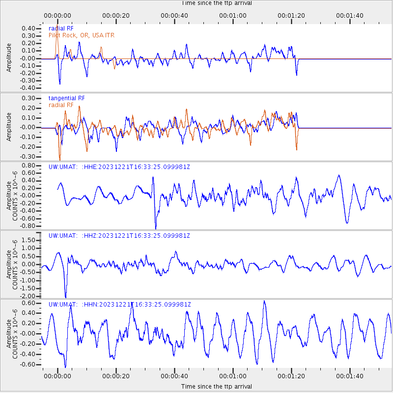
Signal To Noise
| Channel | StoN | STA | LTA |
| UW:UMAT: :HHZ:20231221T16:33:25.099981Z | 4.7301126 | 8.013032E-7 | 1.6940467E-7 |
| UW:UMAT: :HHN:20231221T16:33:25.099981Z | 1.6602045 | 3.8187486E-7 | 2.3001675E-7 |
| UW:UMAT: :HHE:20231221T16:33:25.099981Z | 2.3866115 | 3.3334766E-7 | 1.3967403E-7 |
| Arrivals |
| Ps | |
| PpPs | |
| PsPs/PpSs | |


