You are here: Home > Network List > CI - Caltech Regional Seismic Network Stations List
> Station MPM Manuel Prospect Mine, California, USA > Earthquake Result Viewer
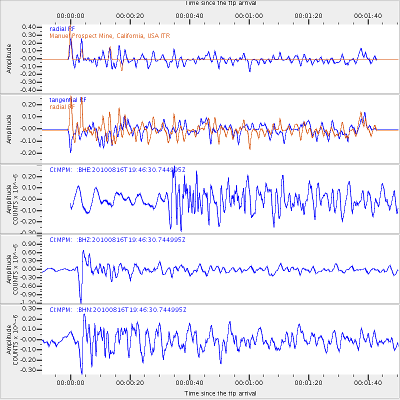
MPM Manuel Prospect Mine, California, USA - Earthquake Result Viewer
*The percent match for this event was below the threshold and hence no stack was calculated.
| Earthquake location: |
Fiji Islands Region |
| Earthquake latitude/longitude: |
-20.8/-178.8 |
| Earthquake time(UTC): |
2010/08/16 (228) 19:35:49 GMT |
| Earthquake Depth: |
603 km |
| Earthquake Magnitude: |
5.7 MB, 6.2 MW, 6.1 MW |
| Earthquake Catalog/Contributor: |
WHDF/NEIC |
|
| Network: |
CI Caltech Regional Seismic Network |
| Station: |
MPM Manuel Prospect Mine, California, USA |
| Lat/Lon: |
36.06 N/117.49 W |
| Elevation: |
185 m |
|
| Distance: |
81.0 deg |
| Az: |
46.046 deg |
| Baz: |
236.227 deg |
| Ray Param: |
$rayparam |
*The percent match for this event was below the threshold and hence was not used in the summary stack. |
|
| Radial Match: |
73.56236 % |
| Radial Bump: |
400 |
| Transverse Match: |
57.38841 % |
| Transverse Bump: |
400 |
| SOD ConfigId: |
319893 |
| Insert Time: |
2011-01-06 00:17:18.368 +0000 |
| GWidth: |
2.5 |
| Max Bumps: |
400 |
| Tol: |
0.001 |
|
Signal To Noise
| Channel | StoN | STA | LTA |
| CI:MPM: :BHZ:20100816T19:46:30.744995Z | 9.717012 | 4.5430068E-7 | 4.6753122E-8 |
| CI:MPM: :BHN:20100816T19:46:30.744995Z | 3.7985618 | 1.4206684E-7 | 3.7400163E-8 |
| CI:MPM: :BHE:20100816T19:46:30.744995Z | 2.1346111 | 1.1978719E-7 | 5.611663E-8 |
| Arrivals |
| Ps | |
| PpPs | |
| PsPs/PpSs | |


