You are here: Home > Network List > CI - Caltech Regional Seismic Network Stations List
> Station SMM Simmler, CA, USA > Earthquake Result Viewer
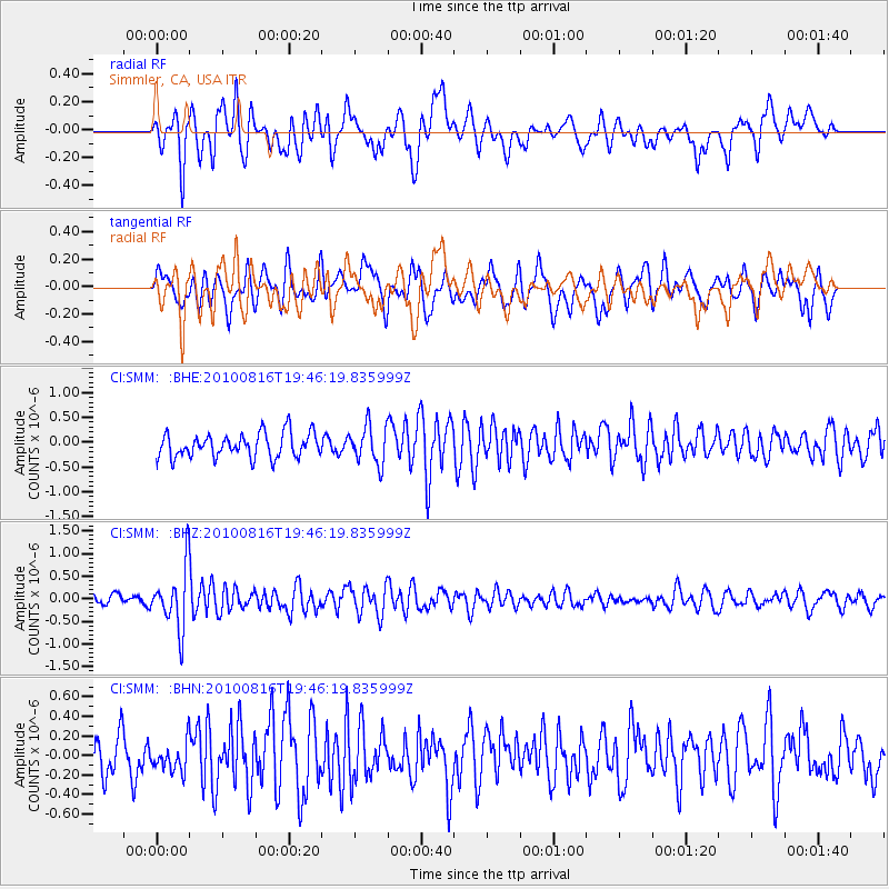
SMM Simmler, CA, USA - Earthquake Result Viewer
*The percent match for this event was below the threshold and hence no stack was calculated.
| Earthquake location: |
Fiji Islands Region |
| Earthquake latitude/longitude: |
-20.8/-178.8 |
| Earthquake time(UTC): |
2010/08/16 (228) 19:35:49 GMT |
| Earthquake Depth: |
603 km |
| Earthquake Magnitude: |
5.7 MB, 6.2 MW, 6.1 MW |
| Earthquake Catalog/Contributor: |
WHDF/NEIC |
|
| Network: |
CI Caltech Regional Seismic Network |
| Station: |
SMM Simmler, CA, USA |
| Lat/Lon: |
35.31 N/120.00 W |
| Elevation: |
599 m |
|
| Distance: |
78.9 deg |
| Az: |
45.492 deg |
| Baz: |
234.674 deg |
| Ray Param: |
$rayparam |
*The percent match for this event was below the threshold and hence was not used in the summary stack. |
|
| Radial Match: |
60.70503 % |
| Radial Bump: |
400 |
| Transverse Match: |
57.665028 % |
| Transverse Bump: |
400 |
| SOD ConfigId: |
319893 |
| Insert Time: |
2011-01-06 00:17:58.574 +0000 |
| GWidth: |
2.5 |
| Max Bumps: |
400 |
| Tol: |
0.001 |
|
Signal To Noise
| Channel | StoN | STA | LTA |
| CI:SMM: :BHZ:20100816T19:46:19.835999Z | 5.6131744 | 6.696354E-7 | 1.192971E-7 |
| CI:SMM: :BHN:20100816T19:46:19.835999Z | 0.6685131 | 1.4274264E-7 | 2.1352257E-7 |
| CI:SMM: :BHE:20100816T19:46:19.835999Z | 1.5695257 | 3.8487008E-7 | 2.4521427E-7 |
| Arrivals |
| Ps | |
| PpPs | |
| PsPs/PpSs | |


