You are here: Home > Network List > IW - Intermountain West Stations List
> Station MOOW Moose Ponds, Wyoming, USA > Earthquake Result Viewer
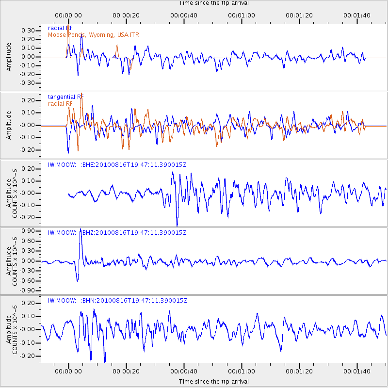
MOOW Moose Ponds, Wyoming, USA - Earthquake Result Viewer
*The percent match for this event was below the threshold and hence no stack was calculated.
| Earthquake location: |
Fiji Islands Region |
| Earthquake latitude/longitude: |
-20.8/-178.8 |
| Earthquake time(UTC): |
2010/08/16 (228) 19:35:49 GMT |
| Earthquake Depth: |
603 km |
| Earthquake Magnitude: |
5.7 MB, 6.2 MW, 6.1 MW |
| Earthquake Catalog/Contributor: |
WHDF/NEIC |
|
| Network: |
IW Intermountain West |
| Station: |
MOOW Moose Ponds, Wyoming, USA |
| Lat/Lon: |
43.75 N/110.74 W |
| Elevation: |
2128 m |
|
| Distance: |
89.4 deg |
| Az: |
42.248 deg |
| Baz: |
240.23 deg |
| Ray Param: |
$rayparam |
*The percent match for this event was below the threshold and hence was not used in the summary stack. |
|
| Radial Match: |
68.60969 % |
| Radial Bump: |
400 |
| Transverse Match: |
62.4904 % |
| Transverse Bump: |
400 |
| SOD ConfigId: |
319893 |
| Insert Time: |
2011-01-06 00:21:26.446 +0000 |
| GWidth: |
2.5 |
| Max Bumps: |
400 |
| Tol: |
0.001 |
|
Signal To Noise
| Channel | StoN | STA | LTA |
| IW:MOOW: :BHZ:20100816T19:47:11.390015Z | 8.624434 | 3.9363215E-7 | 4.5641503E-8 |
| IW:MOOW: :BHN:20100816T19:47:11.390015Z | 2.5381322 | 8.990889E-8 | 3.542325E-8 |
| IW:MOOW: :BHE:20100816T19:47:11.390015Z | 1.5244585 | 4.0548105E-8 | 2.6598366E-8 |
| Arrivals |
| Ps | |
| PpPs | |
| PsPs/PpSs | |


