You are here: Home > Network List > CI - Caltech Regional Seismic Network Stations List
> Station SWS Sam W. Stewart, Westmorland, CA, USA > Earthquake Result Viewer
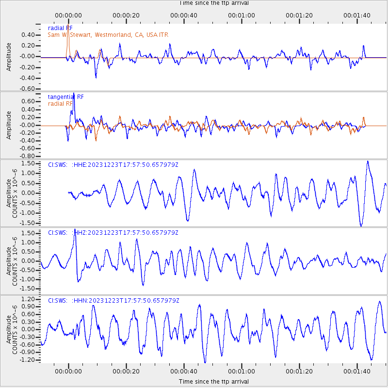
SWS Sam W. Stewart, Westmorland, CA, USA - Earthquake Result Viewer
*The percent match for this event was below the threshold and hence no stack was calculated.
| Earthquake location: |
Near East Coast Of Kamchatka |
| Earthquake latitude/longitude: |
52.0/159.0 |
| Earthquake time(UTC): |
2023/12/23 (357) 17:48:03 GMT |
| Earthquake Depth: |
29 km |
| Earthquake Magnitude: |
5.8 Mww |
| Earthquake Catalog/Contributor: |
NEIC PDE/us |
|
| Network: |
CI Caltech Regional Seismic Network |
| Station: |
SWS Sam W. Stewart, Westmorland, CA, USA |
| Lat/Lon: |
32.94 N/115.80 W |
| Elevation: |
140 m |
|
| Distance: |
62.1 deg |
| Az: |
71.511 deg |
| Baz: |
315.732 deg |
| Ray Param: |
$rayparam |
*The percent match for this event was below the threshold and hence was not used in the summary stack. |
|
| Radial Match: |
66.686005 % |
| Radial Bump: |
400 |
| Transverse Match: |
71.31679 % |
| Transverse Bump: |
383 |
| SOD ConfigId: |
33437571 |
| Insert Time: |
2024-01-06 17:57:51.799 +0000 |
| GWidth: |
2.5 |
| Max Bumps: |
400 |
| Tol: |
0.001 |
|
Signal To Noise
| Channel | StoN | STA | LTA |
| CI:SWS: :HHZ:20231223T17:57:50.657979Z | 2.5886855 | 8.3621893E-7 | 3.230284E-7 |
| CI:SWS: :HHN:20231223T17:57:50.657979Z | 0.6149103 | 2.3203229E-7 | 3.7734333E-7 |
| CI:SWS: :HHE:20231223T17:57:50.657979Z | 1.4088852 | 4.2878733E-7 | 3.043451E-7 |
| Arrivals |
| Ps | |
| PpPs | |
| PsPs/PpSs | |


