You are here: Home > Network List > MY - Malaysian National Seismic Network Stations List
> Station KOM Kota Tinggi > Earthquake Result Viewer
KOM Kota Tinggi - Earthquake Result Viewer
| Earthquake location: |
Fiji Islands Region |
| Earthquake latitude/longitude: |
-20.8/-178.8 |
| Earthquake time(UTC): |
2010/08/16 (228) 19:35:49 GMT |
| Earthquake Depth: |
603 km |
| Earthquake Magnitude: |
5.7 MB, 6.2 MW, 6.1 MW |
| Earthquake Catalog/Contributor: |
WHDF/NEIC |
|
| Network: |
MY Malaysian National Seismic Network |
| Station: |
KOM Kota Tinggi |
| Lat/Lon: |
1.79 N/103.85 E |
| Elevation: |
49 m |
|
| Distance: |
78.8 deg |
| Az: |
276.231 deg |
| Baz: |
111.481 deg |
| Ray Param: |
0.04750243 |
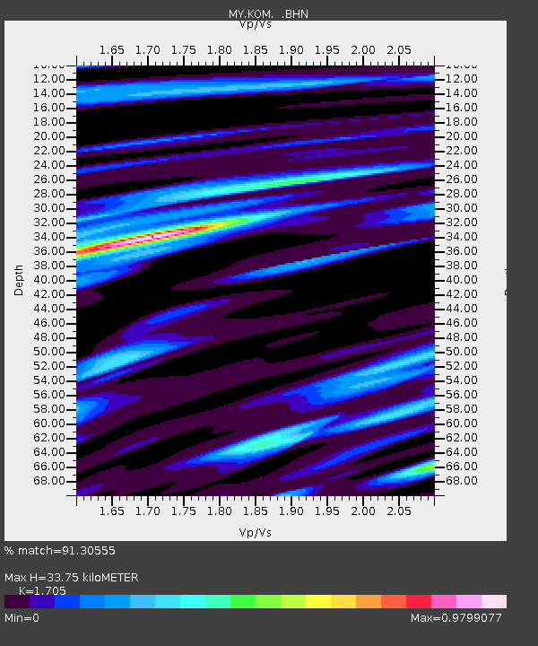
| Estimated Moho Depth: |
33.75 km |
| Estimated Crust Vp/Vs: |
1.71 |
| Assumed Crust Vp: |
6.24 km/s |
| Estimated Crust Vs: |
3.66 km/s |
| Estimated Crust Poisson's Ratio: |
0.24 |
|
| Radial Match: |
91.30555 % |
| Radial Bump: |
400 |
| Transverse Match: |
84.69368 % |
| Transverse Bump: |
400 |
| SOD ConfigId: |
319893 |
| Insert Time: |
2011-01-06 00:22:42.741 +0000 |
| GWidth: |
2.5 |
| Max Bumps: |
400 |
| Tol: |
0.001 |
|

Signal To Noise
| Channel | StoN | STA | LTA |
| MY:KOM: :BHZ:20100816T19:46:19.469971Z | 37.947598 | 2.7462E-6 | 7.2368216E-8 |
| MY:KOM: :BHN:20100816T19:46:19.469971Z | 8.448932 | 4.3526407E-7 | 5.1517056E-8 |
| MY:KOM: :BHE:20100816T19:46:19.469971Z | 14.331627 | 1.0412355E-6 | 7.265299E-8 |
| Arrivals |
| Ps | 3.9 SECOND |
| PpPs | 14 SECOND |
| PsPs/PpSs | 18 SECOND |


