You are here: Home > Network List > IW - Intermountain West Stations List
> Station MOOW Moose Ponds, Wyoming, USA > Earthquake Result Viewer
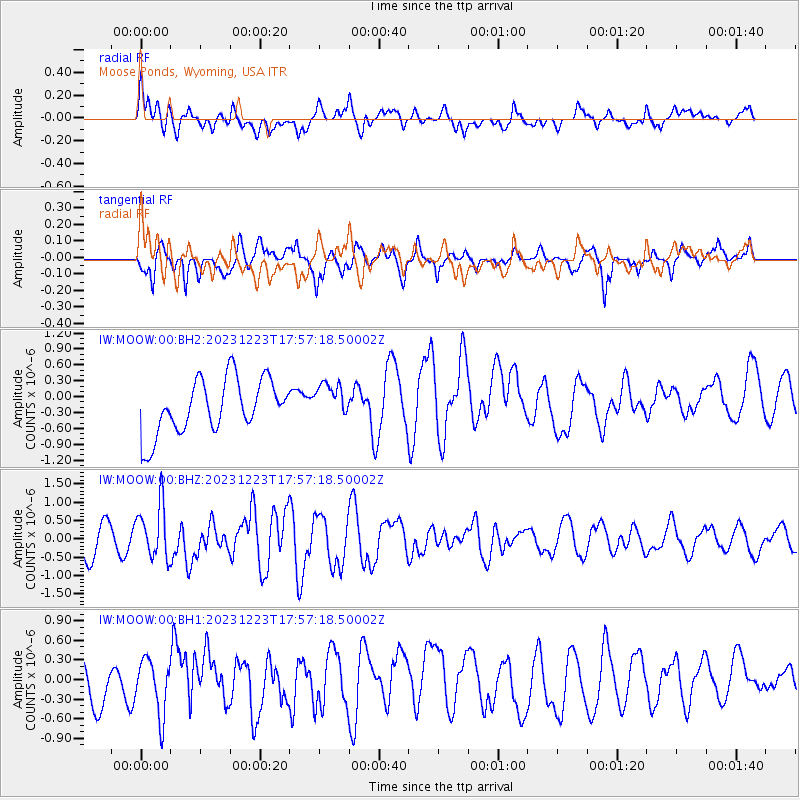
MOOW Moose Ponds, Wyoming, USA - Earthquake Result Viewer
*The percent match for this event was below the threshold and hence no stack was calculated.
| Earthquake location: |
Near East Coast Of Kamchatka |
| Earthquake latitude/longitude: |
52.0/159.0 |
| Earthquake time(UTC): |
2023/12/23 (357) 17:48:03 GMT |
| Earthquake Depth: |
29 km |
| Earthquake Magnitude: |
5.8 Mww |
| Earthquake Catalog/Contributor: |
NEIC PDE/us |
|
| Network: |
IW Intermountain West |
| Station: |
MOOW Moose Ponds, Wyoming, USA |
| Lat/Lon: |
43.75 N/110.74 W |
| Elevation: |
2128 m |
|
| Distance: |
57.4 deg |
| Az: |
59.351 deg |
| Baz: |
312.717 deg |
| Ray Param: |
$rayparam |
*The percent match for this event was below the threshold and hence was not used in the summary stack. |
|
| Radial Match: |
43.39121 % |
| Radial Bump: |
400 |
| Transverse Match: |
55.437096 % |
| Transverse Bump: |
298 |
| SOD ConfigId: |
33437571 |
| Insert Time: |
2024-01-06 18:04:54.364 +0000 |
| GWidth: |
2.5 |
| Max Bumps: |
400 |
| Tol: |
0.001 |
|
Signal To Noise
| Channel | StoN | STA | LTA |
| IW:MOOW:00:BHZ:20231223T17:57:18.50002Z | 2.0584288 | 7.354598E-7 | 3.5729187E-7 |
| IW:MOOW:00:BH1:20231223T17:57:18.50002Z | 0.9698231 | 4.2098574E-7 | 4.3408508E-7 |
| IW:MOOW:00:BH2:20231223T17:57:18.50002Z | 0.6701244 | 3.4244206E-7 | 5.110127E-7 |
| Arrivals |
| Ps | |
| PpPs | |
| PsPs/PpSs | |


