You are here: Home > Network List > US - United States National Seismic Network Stations List
> Station CBKS Cedar Bluff, Kansas, USA > Earthquake Result Viewer
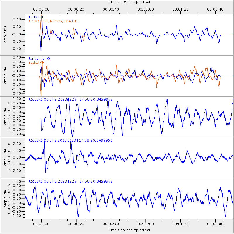
CBKS Cedar Bluff, Kansas, USA - Earthquake Result Viewer
*The percent match for this event was below the threshold and hence no stack was calculated.
| Earthquake location: |
Near East Coast Of Kamchatka |
| Earthquake latitude/longitude: |
52.0/159.0 |
| Earthquake time(UTC): |
2023/12/23 (357) 17:48:03 GMT |
| Earthquake Depth: |
29 km |
| Earthquake Magnitude: |
5.8 Mww |
| Earthquake Catalog/Contributor: |
NEIC PDE/us |
|
| Network: |
US United States National Seismic Network |
| Station: |
CBKS Cedar Bluff, Kansas, USA |
| Lat/Lon: |
38.81 N/99.74 W |
| Elevation: |
677 m |
|
| Distance: |
66.7 deg |
| Az: |
56.522 deg |
| Baz: |
318.641 deg |
| Ray Param: |
$rayparam |
*The percent match for this event was below the threshold and hence was not used in the summary stack. |
|
| Radial Match: |
63.43136 % |
| Radial Bump: |
400 |
| Transverse Match: |
60.49019 % |
| Transverse Bump: |
400 |
| SOD ConfigId: |
33437571 |
| Insert Time: |
2024-01-06 18:22:01.957 +0000 |
| GWidth: |
2.5 |
| Max Bumps: |
400 |
| Tol: |
0.001 |
|
Signal To Noise
| Channel | StoN | STA | LTA |
| US:CBKS:00:BHZ:20231223T17:58:20.849995Z | 4.1769934 | 1.151861E-6 | 2.757632E-7 |
| US:CBKS:00:BH1:20231223T17:58:20.849995Z | 1.6350787 | 4.1797645E-7 | 2.556308E-7 |
| US:CBKS:00:BH2:20231223T17:58:20.849995Z | 0.5661278 | 3.8275547E-7 | 6.7609375E-7 |
| Arrivals |
| Ps | |
| PpPs | |
| PsPs/PpSs | |


