You are here: Home > Network List > TA - USArray Transportable Network (new EarthScope stations) Stations List
> Station K04D Chiloquin, OR, USA > Earthquake Result Viewer
K04D Chiloquin, OR, USA - Earthquake Result Viewer

| Earthquake location: |
Fiji Islands Region |
| Earthquake latitude/longitude: |
-20.8/-178.8 |
| Earthquake time(UTC): |
2010/08/16 (228) 19:35:49 GMT |
| Earthquake Depth: |
603 km |
| Earthquake Magnitude: |
5.7 MB, 6.2 MW, 6.1 MW |
| Earthquake Catalog/Contributor: |
WHDF/NEIC |
|
| Network: |
TA USArray Transportable Network (new EarthScope stations) |
| Station: |
K04D Chiloquin, OR, USA |
| Lat/Lon: |
42.62 N/121.75 W |
| Elevation: |
1315 m |
|
| Distance: |
82.1 deg |
| Az: |
38.713 deg |
| Baz: |
232.449 deg |
| Ray Param: |
0.045286376 |
| Estimated Moho Depth: |
29.5 km |
| Estimated Crust Vp/Vs: |
2.10 |
| Assumed Crust Vp: |
6.597 km/s |
| Estimated Crust Vs: |
3.145 km/s |
| Estimated Crust Poisson's Ratio: |
0.35 |
|
| Radial Match: |
81.35751 % |
| Radial Bump: |
400 |
| Transverse Match: |
82.81227 % |
| Transverse Bump: |
400 |
| SOD ConfigId: |
319893 |
| Insert Time: |
2011-01-06 00:35:56.144 +0000 |
| GWidth: |
2.5 |
| Max Bumps: |
400 |
| Tol: |
0.001 |
|
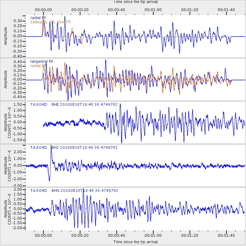
Signal To Noise
| Channel | StoN | STA | LTA |
| TA:K04D: :BHZ:20100816T19:46:36.474976Z | 9.680869 | 1.1343753E-6 | 1.1717701E-7 |
| TA:K04D: :BHN:20100816T19:46:36.474976Z | 2.601775 | 3.0175437E-7 | 1.159802E-7 |
| TA:K04D: :BHE:20100816T19:46:36.474976Z | 2.1271145 | 2.938248E-7 | 1.3813303E-7 |
| Arrivals |
| Ps | 5.0 SECOND |
| PpPs | 14 SECOND |
| PsPs/PpSs | 19 SECOND |


