You are here: Home > Network List > UW - Pacific Northwest Regional Seismic Network Stations List
> Station HOOD Mt Hood Meadows, OR CREST BB SMO > Earthquake Result Viewer
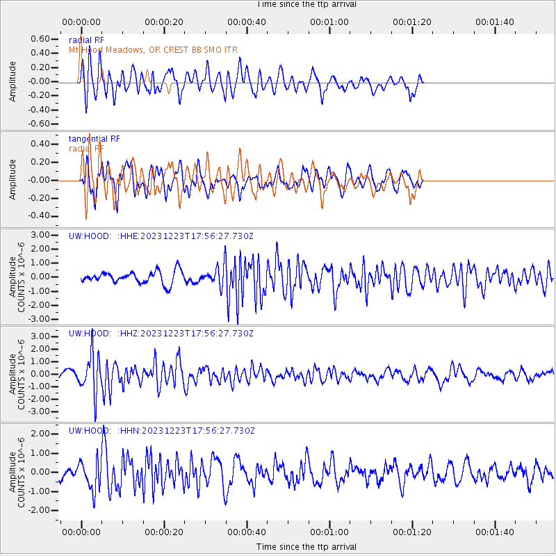
HOOD Mt Hood Meadows, OR CREST BB SMO - Earthquake Result Viewer
*The percent match for this event was below the threshold and hence no stack was calculated.
| Earthquake location: |
Near East Coast Of Kamchatka |
| Earthquake latitude/longitude: |
52.0/159.0 |
| Earthquake time(UTC): |
2023/12/23 (357) 17:48:03 GMT |
| Earthquake Depth: |
29 km |
| Earthquake Magnitude: |
5.8 Mww |
| Earthquake Catalog/Contributor: |
NEIC PDE/us |
|
| Network: |
UW Pacific Northwest Regional Seismic Network |
| Station: |
HOOD Mt Hood Meadows, OR CREST BB SMO |
| Lat/Lon: |
45.32 N/121.65 W |
| Elevation: |
1520 m |
|
| Distance: |
50.4 deg |
| Az: |
64.11 deg |
| Baz: |
307.89 deg |
| Ray Param: |
$rayparam |
*The percent match for this event was below the threshold and hence was not used in the summary stack. |
|
| Radial Match: |
75.16502 % |
| Radial Bump: |
400 |
| Transverse Match: |
75.73899 % |
| Transverse Bump: |
400 |
| SOD ConfigId: |
33437571 |
| Insert Time: |
2024-01-06 18:24:48.147 +0000 |
| GWidth: |
2.5 |
| Max Bumps: |
400 |
| Tol: |
0.001 |
|
Signal To Noise
| Channel | StoN | STA | LTA |
| UW:HOOD: :HHZ:20231223T17:56:27.730Z | 6.7130995 | 1.5817574E-6 | 2.3562251E-7 |
| UW:HOOD: :HHN:20231223T17:56:27.730Z | 2.8702068 | 7.6224023E-7 | 2.655698E-7 |
| UW:HOOD: :HHE:20231223T17:56:27.730Z | 1.5813493 | 6.7233333E-7 | 4.2516436E-7 |
| Arrivals |
| Ps | |
| PpPs | |
| PsPs/PpSs | |


