You are here: Home > Network List > TA - USArray Transportable Network (new EarthScope stations) Stations List
> Station N02D Trinity Center, CA, USA > Earthquake Result Viewer
N02D Trinity Center, CA, USA - Earthquake Result Viewer
| Earthquake location: |
Fiji Islands Region |
| Earthquake latitude/longitude: |
-20.8/-178.8 |
| Earthquake time(UTC): |
2010/08/16 (228) 19:35:49 GMT |
| Earthquake Depth: |
603 km |
| Earthquake Magnitude: |
5.7 MB, 6.2 MW, 6.1 MW |
| Earthquake Catalog/Contributor: |
WHDF/NEIC |
|
| Network: |
TA USArray Transportable Network (new EarthScope stations) |
| Station: |
N02D Trinity Center, CA, USA |
| Lat/Lon: |
40.97 N/122.71 W |
| Elevation: |
937 m |
|
| Distance: |
80.5 deg |
| Az: |
39.59 deg |
| Baz: |
231.95 deg |
| Ray Param: |
0.046348028 |
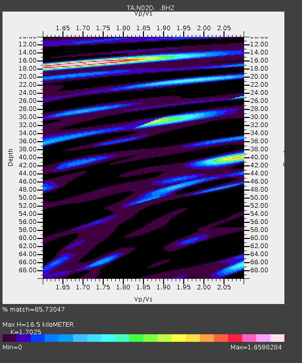
| Estimated Moho Depth: |
16.5 km |
| Estimated Crust Vp/Vs: |
1.70 |
| Assumed Crust Vp: |
6.566 km/s |
| Estimated Crust Vs: |
3.857 km/s |
| Estimated Crust Poisson's Ratio: |
0.24 |
|
| Radial Match: |
85.73047 % |
| Radial Bump: |
400 |
| Transverse Match: |
83.52218 % |
| Transverse Bump: |
400 |
| SOD ConfigId: |
319893 |
| Insert Time: |
2011-01-06 00:36:59.592 +0000 |
| GWidth: |
2.5 |
| Max Bumps: |
400 |
| Tol: |
0.001 |
|

Signal To Noise
| Channel | StoN | STA | LTA |
| TA:N02D: :BHZ:20100816T19:46:28.500Z | 19.858887 | 1.0026889E-6 | 5.049069E-8 |
| TA:N02D: :BHN:20100816T19:46:28.500Z | 4.008894 | 2.5248093E-7 | 6.29802E-8 |
| TA:N02D: :BHE:20100816T19:46:28.500Z | 3.4308128 | 2.1590942E-7 | 6.293244E-8 |
| Arrivals |
| Ps | 1.8 SECOND |
| PpPs | 6.6 SECOND |
| PsPs/PpSs | 8.4 SECOND |


