You are here: Home > Network List > US - United States National Seismic Network Stations List
> Station DGMT Dagmar, Montana, USA > Earthquake Result Viewer
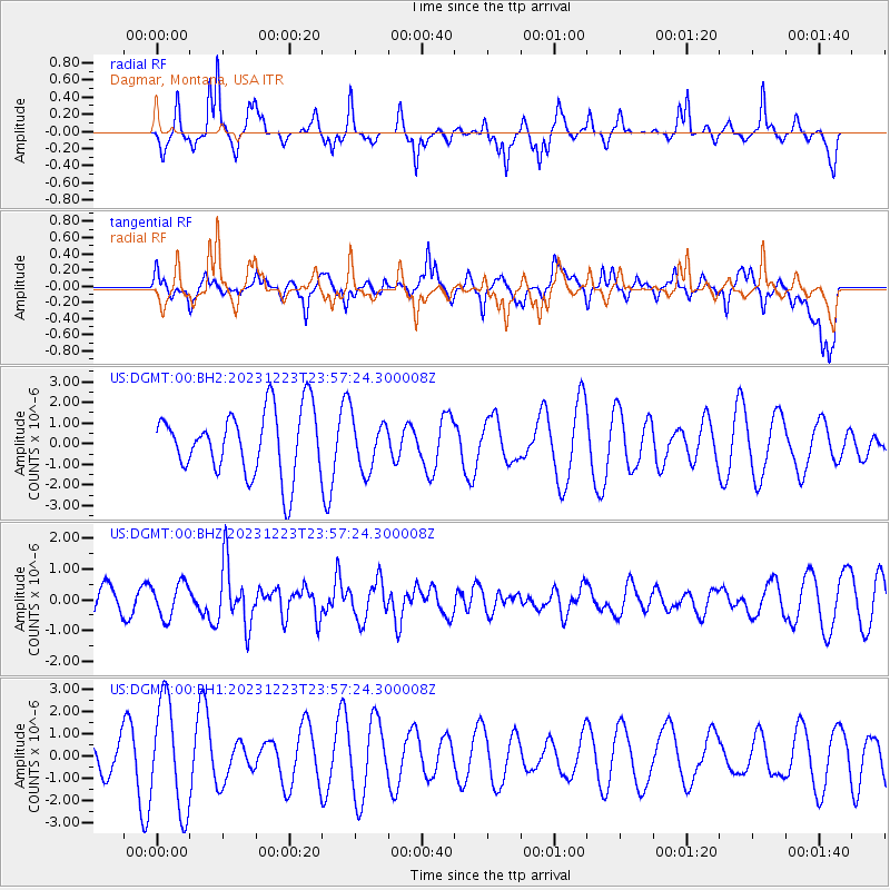
DGMT Dagmar, Montana, USA - Earthquake Result Viewer
*The percent match for this event was below the threshold and hence no stack was calculated.
| Earthquake location: |
Tonga Islands |
| Earthquake latitude/longitude: |
-20.4/-173.4 |
| Earthquake time(UTC): |
2023/12/23 (357) 23:44:46 GMT |
| Earthquake Depth: |
10 km |
| Earthquake Magnitude: |
5.6 mww |
| Earthquake Catalog/Contributor: |
NEIC PDE/us |
|
| Network: |
US United States National Seismic Network |
| Station: |
DGMT Dagmar, Montana, USA |
| Lat/Lon: |
48.47 N/104.20 W |
| Elevation: |
646 m |
|
| Distance: |
92.1 deg |
| Az: |
38.501 deg |
| Baz: |
241.31 deg |
| Ray Param: |
$rayparam |
*The percent match for this event was below the threshold and hence was not used in the summary stack. |
|
| Radial Match: |
58.169823 % |
| Radial Bump: |
310 |
| Transverse Match: |
60.04431 % |
| Transverse Bump: |
400 |
| SOD ConfigId: |
33437571 |
| Insert Time: |
2024-01-07 00:06:57.076 +0000 |
| GWidth: |
2.5 |
| Max Bumps: |
400 |
| Tol: |
0.001 |
|
Signal To Noise
| Channel | StoN | STA | LTA |
| US:DGMT:00:BHZ:20231223T23:57:24.300008Z | 0.8988685 | 5.524182E-7 | 6.1457064E-7 |
| US:DGMT:00:BH1:20231223T23:57:24.300008Z | 2.8143485 | 2.4651663E-6 | 8.7592787E-7 |
| US:DGMT:00:BH2:20231223T23:57:24.300008Z | 0.8073799 | 1.266056E-6 | 1.5681044E-6 |
| Arrivals |
| Ps | |
| PpPs | |
| PsPs/PpSs | |


