You are here: Home > Network List > CN - Canadian National Seismograph Network Stations List
> Station INK INUVIK, NT > Earthquake Result Viewer
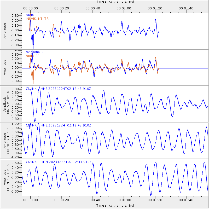
INK INUVIK, NT - Earthquake Result Viewer
*The percent match for this event was below the threshold and hence no stack was calculated.
| Earthquake location: |
Loyalty Islands |
| Earthquake latitude/longitude: |
-20.5/168.9 |
| Earthquake time(UTC): |
2023/12/24 (358) 01:59:40 GMT |
| Earthquake Depth: |
10 km |
| Earthquake Magnitude: |
5.8 mww |
| Earthquake Catalog/Contributor: |
NEIC PDE/us |
|
| Network: |
CN Canadian National Seismograph Network |
| Station: |
INK INUVIK, NT |
| Lat/Lon: |
68.31 N/133.53 W |
| Elevation: |
44 m |
|
| Distance: |
97.9 deg |
| Az: |
18.468 deg |
| Baz: |
232.992 deg |
| Ray Param: |
$rayparam |
*The percent match for this event was below the threshold and hence was not used in the summary stack. |
|
| Radial Match: |
68.66758 % |
| Radial Bump: |
400 |
| Transverse Match: |
58.19936 % |
| Transverse Bump: |
400 |
| SOD ConfigId: |
33437571 |
| Insert Time: |
2024-01-07 02:09:20.353 +0000 |
| GWidth: |
2.5 |
| Max Bumps: |
400 |
| Tol: |
0.001 |
|
Signal To Noise
| Channel | StoN | STA | LTA |
| CN:INK: :HHZ:20231224T02:12:43.910Z | 3.2274246 | 8.163486E-7 | 2.5294116E-7 |
| CN:INK: :HHN:20231224T02:12:43.910Z | 1.5797724 | 2.8988472E-7 | 1.8349779E-7 |
| CN:INK: :HHE:20231224T02:12:43.910Z | 0.74284756 | 3.2023797E-7 | 4.3109512E-7 |
| Arrivals |
| Ps | |
| PpPs | |
| PsPs/PpSs | |


