You are here: Home > Network List > UW - Pacific Northwest Regional Seismic Network Stations List
> Station FISH Seaside, OR, USA > Earthquake Result Viewer
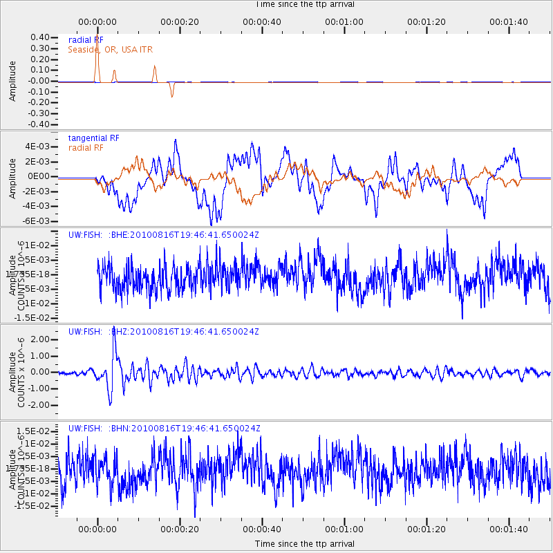
FISH Seaside, OR, USA - Earthquake Result Viewer
*The percent match for this event was below the threshold and hence no stack was calculated.
| Earthquake location: |
Fiji Islands Region |
| Earthquake latitude/longitude: |
-20.8/-178.8 |
| Earthquake time(UTC): |
2010/08/16 (228) 19:35:49 GMT |
| Earthquake Depth: |
603 km |
| Earthquake Magnitude: |
5.7 MB, 6.2 MW, 6.1 MW |
| Earthquake Catalog/Contributor: |
WHDF/NEIC |
|
| Network: |
UW Pacific Northwest Regional Seismic Network |
| Station: |
FISH Seaside, OR, USA |
| Lat/Lon: |
45.93 N/123.56 W |
| Elevation: |
325 m |
|
| Distance: |
83.2 deg |
| Az: |
35.289 deg |
| Baz: |
230.753 deg |
| Ray Param: |
$rayparam |
*The percent match for this event was below the threshold and hence was not used in the summary stack. |
|
| Radial Match: |
49.935127 % |
| Radial Bump: |
400 |
| Transverse Match: |
61.40683 % |
| Transverse Bump: |
400 |
| SOD ConfigId: |
319893 |
| Insert Time: |
2011-01-06 00:43:44.893 +0000 |
| GWidth: |
2.5 |
| Max Bumps: |
400 |
| Tol: |
0.001 |
|
Signal To Noise
| Channel | StoN | STA | LTA |
| UW:FISH: :BHZ:20100816T19:46:41.650024Z | 9.050578 | 1.1412051E-6 | 1.2609195E-7 |
| UW:FISH: :BHN:20100816T19:46:41.650024Z | 1.04477 | 5.640954E-9 | 5.3992304E-9 |
| UW:FISH: :BHE:20100816T19:46:41.650024Z | 1.064012 | 4.159966E-9 | 3.9096983E-9 |
| Arrivals |
| Ps | |
| PpPs | |
| PsPs/PpSs | |


