You are here: Home > Network List > AK - Alaska Regional Network Stations List
> Station MDM Murphy Dome > Earthquake Result Viewer
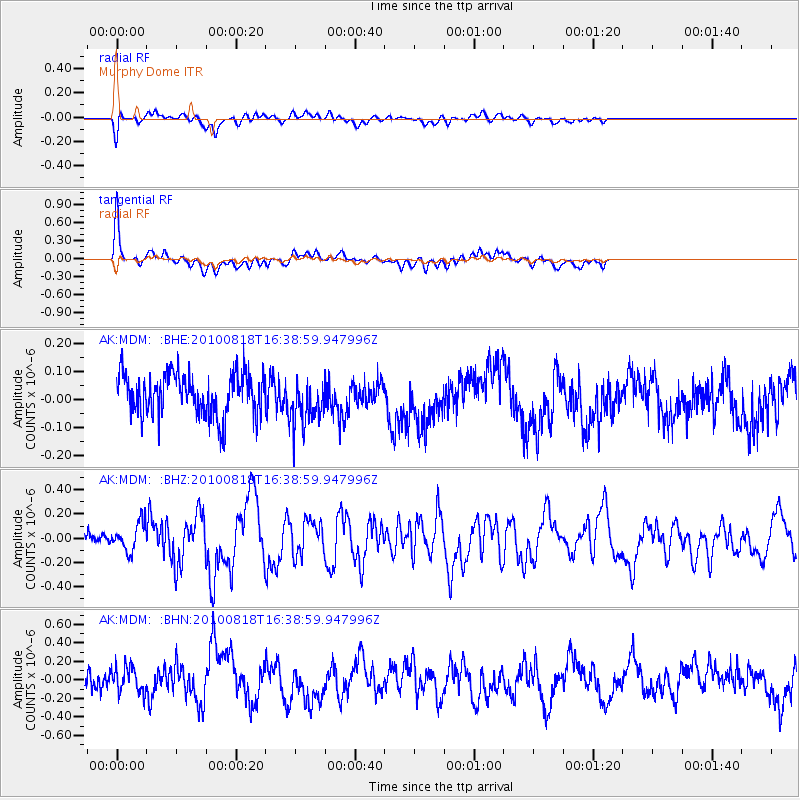
MDM Murphy Dome - Earthquake Result Viewer
*The percent match for this event was below the threshold and hence no stack was calculated.
| Earthquake location: |
South Of Mariana Islands |
| Earthquake latitude/longitude: |
12.2/141.5 |
| Earthquake time(UTC): |
2010/08/18 (230) 16:28:15 GMT |
| Earthquake Depth: |
10 km |
| Earthquake Magnitude: |
5.8 MB, 5.9 MS, 6.3 MW, 6.2 MW |
| Earthquake Catalog/Contributor: |
WHDF/NEIC |
|
| Network: |
AK Alaska Regional Network |
| Station: |
MDM Murphy Dome |
| Lat/Lon: |
64.96 N/148.23 W |
| Elevation: |
634 m |
|
| Distance: |
70.7 deg |
| Az: |
25.121 deg |
| Baz: |
257.19 deg |
| Ray Param: |
$rayparam |
*The percent match for this event was below the threshold and hence was not used in the summary stack. |
|
| Radial Match: |
66.26054 % |
| Radial Bump: |
400 |
| Transverse Match: |
76.54557 % |
| Transverse Bump: |
361 |
| SOD ConfigId: |
319893 |
| Insert Time: |
2011-01-06 00:46:25.044 +0000 |
| GWidth: |
2.5 |
| Max Bumps: |
400 |
| Tol: |
0.001 |
|
Signal To Noise
| Channel | StoN | STA | LTA |
| AK:MDM: :BHZ:20100818T16:38:59.947996Z | 2.692905 | 1.18632016E-7 | 4.405355E-8 |
| AK:MDM: :BHN:20100818T16:38:59.947996Z | 1.1617855 | 1.3728989E-7 | 1.18171464E-7 |
| AK:MDM: :BHE:20100818T16:38:59.947996Z | 1.1170129 | 8.416852E-8 | 7.535143E-8 |
| Arrivals |
| Ps | |
| PpPs | |
| PsPs/PpSs | |


