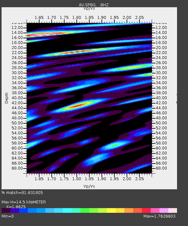
SPBG Mount Spurr - Barrier Glacier - Earthquake Result Viewer

Earthquake location: South Of Mariana Islands
Earthquake latitude/longitude: 12.2/141.5
Earthquake time(UTC): 2010/08/18 (230) 16:28:15 GMT
Earthquake Depth: 10 km
Earthquake Magnitude: 5.8 MB, 5.9 MS, 6.3 MW, 6.2 MW
Earthquake Catalog/Contributor: WHDF/NEIC
Network: AV Alaska Volcano Observatory
Station: SPBG Mount Spurr - Barrier Glacier
Lat/Lon: 61.26 N/152.37 W
Elevation: 1087 m
Distance: 67.9 deg
Az: 28.48 deg
Baz: 254.688 deg
Ray Param: 0.05663125
Estimated Moho Depth: 14.5 km
Estimated Crust Vp/Vs: 1.66
Assumed Crust Vp: 6.566 km/s
Estimated Crust Vs: 3.95 km/s
Estimated Crust Poisson's Ratio: 0.22
Radial Match: 81.631805 %
Radial Bump: 400
Transverse Match: 83.46662 %
Transverse Bump: 400
SOD ConfigId: 319893
Insert Time: 2011-01-06 00:48:10.295 +0000
GWidth: 2.5
Max Bumps: 400
Tol: 0.001

Signal To Noise

ChannelStoNSTALTA
AV:SPBG: :BHZ:20100818T16:38:43.080015Z6.76759676.064321E-78.9608186E-8
AV:SPBG: :BHN:20100818T16:38:43.080015Z2.05912543.031981E-71.4724606E-7
AV:SPBG: :BHE:20100818T16:38:43.080015Z1.77756623.1614937E-71.7785518E-7
Arrivals
Ps1.5 SECOND
PpPs5.6 SECOND
PsPs/PpSs7.2 SECOND