You are here: Home > Network List > CI - Caltech Regional Seismic Network Stations List
> Station SLA SLA, Trona, CA, USA > Earthquake Result Viewer
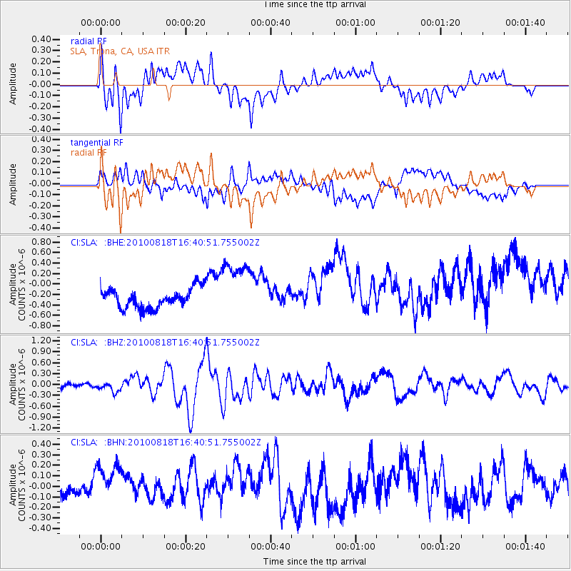
SLA SLA, Trona, CA, USA - Earthquake Result Viewer
*The percent match for this event was below the threshold and hence no stack was calculated.
| Earthquake location: |
South Of Mariana Islands |
| Earthquake latitude/longitude: |
12.2/141.5 |
| Earthquake time(UTC): |
2010/08/18 (230) 16:28:15 GMT |
| Earthquake Depth: |
10 km |
| Earthquake Magnitude: |
5.8 MB, 5.9 MS, 6.3 MW, 6.2 MW |
| Earthquake Catalog/Contributor: |
WHDF/NEIC |
|
| Network: |
CI Caltech Regional Seismic Network |
| Station: |
SLA SLA, Trona, CA, USA |
| Lat/Lon: |
35.89 N/117.28 W |
| Elevation: |
1174 m |
|
| Distance: |
91.8 deg |
| Az: |
52.837 deg |
| Baz: |
286.377 deg |
| Ray Param: |
$rayparam |
*The percent match for this event was below the threshold and hence was not used in the summary stack. |
|
| Radial Match: |
49.917824 % |
| Radial Bump: |
400 |
| Transverse Match: |
53.48215 % |
| Transverse Bump: |
400 |
| SOD ConfigId: |
319893 |
| Insert Time: |
2011-01-06 00:50:06.240 +0000 |
| GWidth: |
2.5 |
| Max Bumps: |
400 |
| Tol: |
0.001 |
|
Signal To Noise
| Channel | StoN | STA | LTA |
| CI:SLA: :BHZ:20100818T16:40:51.755002Z | 2.089406 | 1.3953746E-7 | 6.678332E-8 |
| CI:SLA: :BHN:20100818T16:40:51.755002Z | 2.3100152 | 2.2522643E-7 | 9.749998E-8 |
| CI:SLA: :BHE:20100818T16:40:51.755002Z | 3.0876513 | 5.7561545E-7 | 1.8642501E-7 |
| Arrivals |
| Ps | |
| PpPs | |
| PsPs/PpSs | |


