You are here: Home > Network List > CN - Canadian National Seismograph Network Stations List
> Station WHY Whitehorse, YT > Earthquake Result Viewer
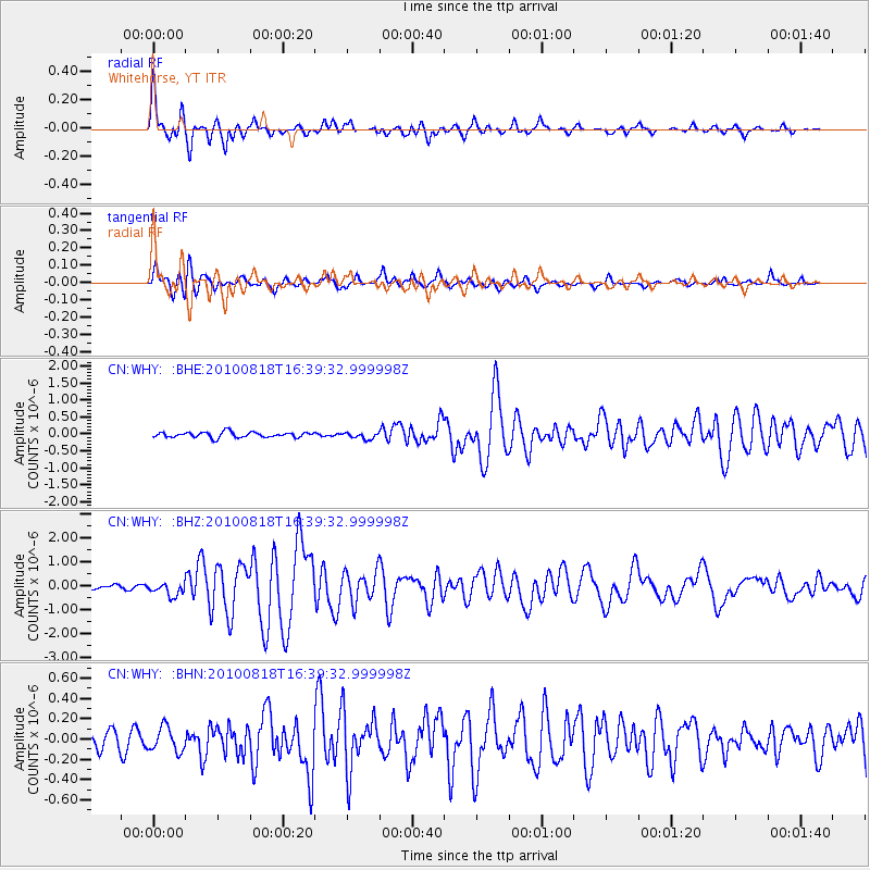
WHY Whitehorse, YT - Earthquake Result Viewer

| Earthquake location: |
South Of Mariana Islands |
| Earthquake latitude/longitude: |
12.2/141.5 |
| Earthquake time(UTC): |
2010/08/18 (230) 16:28:15 GMT |
| Earthquake Depth: |
10 km |
| Earthquake Magnitude: |
5.8 MB, 5.9 MS, 6.3 MW, 6.2 MW |
| Earthquake Catalog/Contributor: |
WHDF/NEIC |
|
| Network: |
CN Canadian National Seismograph Network |
| Station: |
WHY Whitehorse, YT |
| Lat/Lon: |
60.66 N/134.88 W |
| Elevation: |
1292 m |
|
| Distance: |
76.3 deg |
| Az: |
30.25 deg |
| Baz: |
270.527 deg |
| Ray Param: |
0.051088076 |
| Estimated Moho Depth: |
11.0 km |
| Estimated Crust Vp/Vs: |
1.73 |
| Assumed Crust Vp: |
6.419 km/s |
| Estimated Crust Vs: |
3.705 km/s |
| Estimated Crust Poisson's Ratio: |
0.25 |
|
| Radial Match: |
94.06588 % |
| Radial Bump: |
400 |
| Transverse Match: |
82.18415 % |
| Transverse Bump: |
400 |
| SOD ConfigId: |
319893 |
| Insert Time: |
2011-01-06 00:51:20.334 +0000 |
| GWidth: |
2.5 |
| Max Bumps: |
400 |
| Tol: |
0.001 |
|
Signal To Noise
| Channel | StoN | STA | LTA |
| CN:WHY: :BHZ:20100818T16:39:32.999998Z | 3.1931596 | 2.7830768E-7 | 8.715746E-8 |
| CN:WHY: :BHN:20100818T16:39:32.999998Z | 1.2133441 | 1.205731E-7 | 9.937255E-8 |
| CN:WHY: :BHE:20100818T16:39:32.999998Z | 1.1821796 | 9.277325E-8 | 7.847645E-8 |
| Arrivals |
| Ps | 1.3 SECOND |
| PpPs | 4.5 SECOND |
| PsPs/PpSs | 5.8 SECOND |


