You are here: Home > Network List > US - United States National Seismic Network Stations List
> Station MNTX Cornudas Mountains, Texas, USA > Earthquake Result Viewer
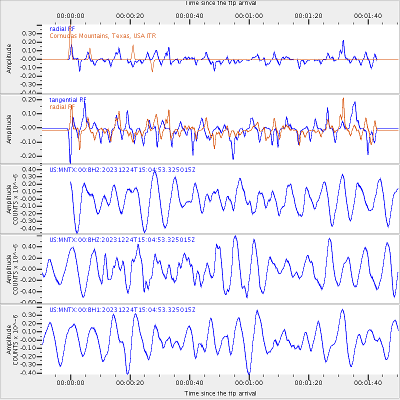
MNTX Cornudas Mountains, Texas, USA - Earthquake Result Viewer
*The percent match for this event was below the threshold and hence no stack was calculated.
| Earthquake location: |
Tonga Islands |
| Earthquake latitude/longitude: |
-20.9/-173.8 |
| Earthquake time(UTC): |
2023/12/24 (358) 14:52:55 GMT |
| Earthquake Depth: |
10 km |
| Earthquake Magnitude: |
5.4 Mww |
| Earthquake Catalog/Contributor: |
NEIC PDE/us |
|
| Network: |
US United States National Seismic Network |
| Station: |
MNTX Cornudas Mountains, Texas, USA |
| Lat/Lon: |
31.70 N/105.38 W |
| Elevation: |
405 m |
|
| Distance: |
83.8 deg |
| Az: |
52.851 deg |
| Baz: |
240.932 deg |
| Ray Param: |
$rayparam |
*The percent match for this event was below the threshold and hence was not used in the summary stack. |
|
| Radial Match: |
49.954426 % |
| Radial Bump: |
392 |
| Transverse Match: |
39.866848 % |
| Transverse Bump: |
328 |
| SOD ConfigId: |
33437571 |
| Insert Time: |
2024-01-07 15:16:05.234 +0000 |
| GWidth: |
2.5 |
| Max Bumps: |
400 |
| Tol: |
0.001 |
|
Signal To Noise
| Channel | StoN | STA | LTA |
| US:MNTX:00:BHZ:20231224T15:04:53.325015Z | 1.8740735 | 3.3120835E-7 | 1.7673179E-7 |
| US:MNTX:00:BH1:20231224T15:04:53.325015Z | 1.2412207 | 1.430595E-7 | 1.15257095E-7 |
| US:MNTX:00:BH2:20231224T15:04:53.325015Z | 1.3641049 | 2.3291226E-7 | 1.7074365E-7 |
| Arrivals |
| Ps | |
| PpPs | |
| PsPs/PpSs | |


