You are here: Home > Network List > US - United States National Seismic Network Stations List
> Station MSO Missoula, Montana, USA > Earthquake Result Viewer
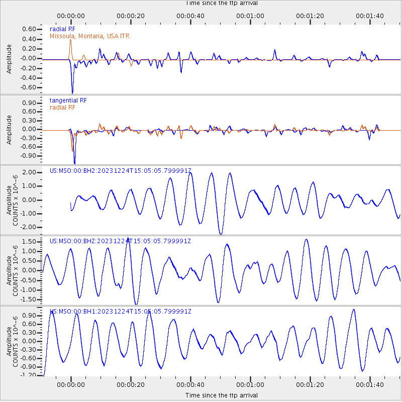
MSO Missoula, Montana, USA - Earthquake Result Viewer
*The percent match for this event was below the threshold and hence no stack was calculated.
| Earthquake location: |
Tonga Islands |
| Earthquake latitude/longitude: |
-20.9/-173.8 |
| Earthquake time(UTC): |
2023/12/24 (358) 14:52:55 GMT |
| Earthquake Depth: |
10 km |
| Earthquake Magnitude: |
5.4 Mww |
| Earthquake Catalog/Contributor: |
NEIC PDE/us |
|
| Network: |
US United States National Seismic Network |
| Station: |
MSO Missoula, Montana, USA |
| Lat/Lon: |
46.83 N/113.94 W |
| Elevation: |
1264 m |
|
| Distance: |
86.3 deg |
| Az: |
36.497 deg |
| Baz: |
234.067 deg |
| Ray Param: |
$rayparam |
*The percent match for this event was below the threshold and hence was not used in the summary stack. |
|
| Radial Match: |
63.55884 % |
| Radial Bump: |
377 |
| Transverse Match: |
88.41279 % |
| Transverse Bump: |
346 |
| SOD ConfigId: |
33437571 |
| Insert Time: |
2024-01-07 15:16:07.224 +0000 |
| GWidth: |
2.5 |
| Max Bumps: |
400 |
| Tol: |
0.001 |
|
Signal To Noise
| Channel | StoN | STA | LTA |
| US:MSO:00:BHZ:20231224T15:05:05.799991Z | 1.8267574 | 8.9785897E-7 | 4.915042E-7 |
| US:MSO:00:BH1:20231224T15:05:05.799991Z | 1.1167666 | 5.92916E-7 | 5.309221E-7 |
| US:MSO:00:BH2:20231224T15:05:05.799991Z | 2.3557506 | 1.0986412E-6 | 4.6636566E-7 |
| Arrivals |
| Ps | |
| PpPs | |
| PsPs/PpSs | |


