You are here: Home > Network List > IW - Intermountain West Stations List
> Station PLID Pearl Lake, Idaho, USA > Earthquake Result Viewer
PLID Pearl Lake, Idaho, USA - Earthquake Result Viewer

| Earthquake location: |
South Of Mariana Islands |
| Earthquake latitude/longitude: |
12.2/141.5 |
| Earthquake time(UTC): |
2010/08/18 (230) 16:28:15 GMT |
| Earthquake Depth: |
10 km |
| Earthquake Magnitude: |
5.8 MB, 5.9 MS, 6.3 MW, 6.2 MW |
| Earthquake Catalog/Contributor: |
WHDF/NEIC |
|
| Network: |
IW Intermountain West |
| Station: |
PLID Pearl Lake, Idaho, USA |
| Lat/Lon: |
45.09 N/116.00 W |
| Elevation: |
2164 m |
|
| Distance: |
90.1 deg |
| Az: |
43.761 deg |
| Baz: |
287.357 deg |
| Ray Param: |
0.04170007 |
| Estimated Moho Depth: |
43.0 km |
| Estimated Crust Vp/Vs: |
1.71 |
| Assumed Crust Vp: |
6.571 km/s |
| Estimated Crust Vs: |
3.843 km/s |
| Estimated Crust Poisson's Ratio: |
0.24 |
|
| Radial Match: |
90.73658 % |
| Radial Bump: |
400 |
| Transverse Match: |
76.30208 % |
| Transverse Bump: |
400 |
| SOD ConfigId: |
319893 |
| Insert Time: |
2011-01-06 00:53:25.747 +0000 |
| GWidth: |
2.5 |
| Max Bumps: |
400 |
| Tol: |
0.001 |
|
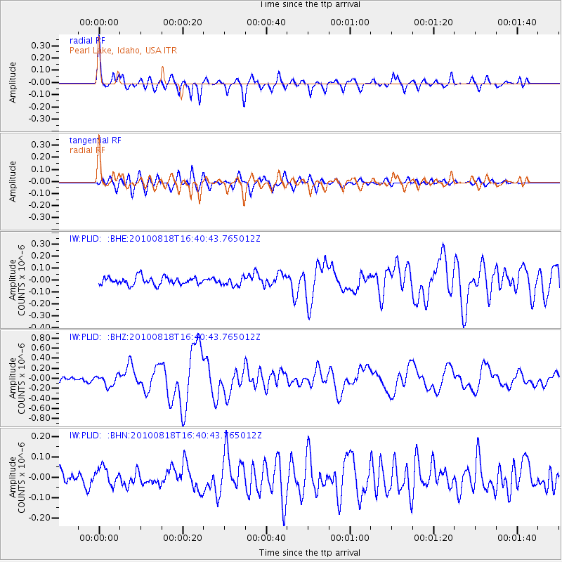
Signal To Noise
| Channel | StoN | STA | LTA |
| IW:PLID: :BHZ:20100818T16:40:43.765012Z | 2.7991679 | 1.11963104E-7 | 3.999871E-8 |
| IW:PLID: :BHN:20100818T16:40:43.765012Z | 1.5791408 | 4.362361E-8 | 2.7624903E-8 |
| IW:PLID: :BHE:20100818T16:40:43.765012Z | 1.0982893 | 3.5600554E-8 | 3.241455E-8 |
| Arrivals |
| Ps | 4.8 SECOND |
| PpPs | 17 SECOND |
| PsPs/PpSs | 22 SECOND |


