You are here: Home > Network List > AK - Alaska Regional Network Stations List
> Station B18K Kokolik River, AK, USA > Earthquake Result Viewer
B18K Kokolik River, AK, USA - Earthquake Result Viewer
| Earthquake location: |
Kuril Islands |
| Earthquake latitude/longitude: |
44.6/149.0 |
| Earthquake time(UTC): |
2023/12/28 (362) 09:15:15 GMT |
| Earthquake Depth: |
24 km |
| Earthquake Magnitude: |
6.5 Mww |
| Earthquake Catalog/Contributor: |
NEIC PDE/us |
|
| Network: |
AK Alaska Regional Network |
| Station: |
B18K Kokolik River, AK, USA |
| Lat/Lon: |
69.36 N/161.80 W |
| Elevation: |
222 m |
|
| Distance: |
35.0 deg |
| Az: |
27.933 deg |
| Baz: |
250.784 deg |
| Ray Param: |
0.07744677 |
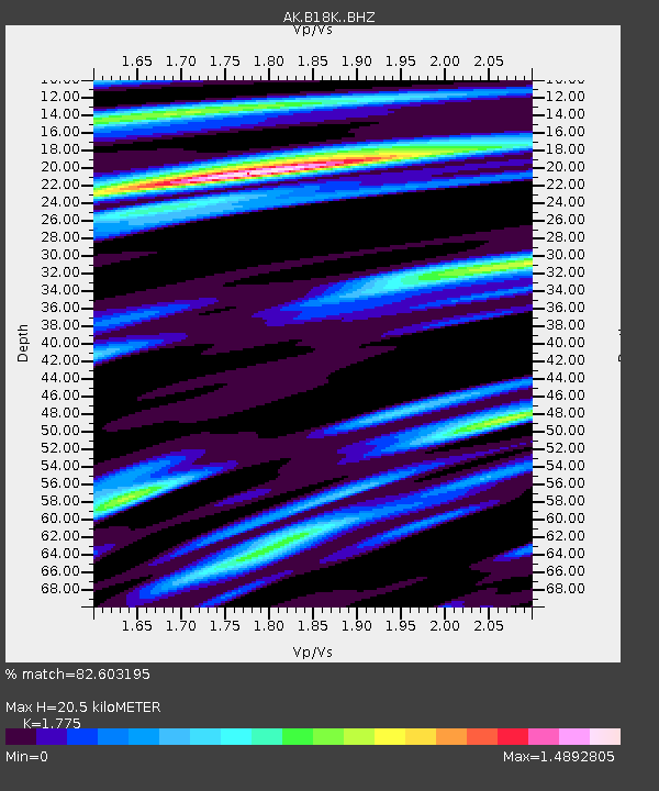
| Estimated Moho Depth: |
20.5 km |
| Estimated Crust Vp/Vs: |
1.77 |
| Assumed Crust Vp: |
5.906 km/s |
| Estimated Crust Vs: |
3.328 km/s |
| Estimated Crust Poisson's Ratio: |
0.27 |
|
| Radial Match: |
82.603195 % |
| Radial Bump: |
400 |
| Transverse Match: |
71.532104 % |
| Transverse Bump: |
400 |
| SOD ConfigId: |
33437571 |
| Insert Time: |
2024-01-11 09:21:29.200 +0000 |
| GWidth: |
2.5 |
| Max Bumps: |
400 |
| Tol: |
0.001 |
|

Signal To Noise
| Channel | StoN | STA | LTA |
| AK:B18K: :BHZ:20231228T09:21:34.839991Z | 4.2041163 | 2.9293026E-6 | 6.967701E-7 |
| AK:B18K: :BHN:20231228T09:21:34.839991Z | 1.2423137 | 5.19458E-7 | 4.1813752E-7 |
| AK:B18K: :BHE:20231228T09:21:34.839991Z | 1.3873606 | 1.2749476E-6 | 9.1897357E-7 |
| Arrivals |
| Ps | 2.9 SECOND |
| PpPs | 9.0 SECOND |
| PsPs/PpSs | 12 SECOND |


