You are here: Home > Network List > AK - Alaska Regional Network Stations List
> Station F20K Avaraart Lake, AK, USA > Earthquake Result Viewer
F20K Avaraart Lake, AK, USA - Earthquake Result Viewer
| Earthquake location: |
Kuril Islands |
| Earthquake latitude/longitude: |
44.6/149.0 |
| Earthquake time(UTC): |
2023/12/28 (362) 09:15:15 GMT |
| Earthquake Depth: |
24 km |
| Earthquake Magnitude: |
6.5 Mww |
| Earthquake Catalog/Contributor: |
NEIC PDE/us |
|
| Network: |
AK Alaska Regional Network |
| Station: |
F20K Avaraart Lake, AK, USA |
| Lat/Lon: |
67.05 N/155.73 W |
| Elevation: |
136 m |
|
| Distance: |
36.6 deg |
| Az: |
32.751 deg |
| Baz: |
260.334 deg |
| Ray Param: |
0.076601125 |
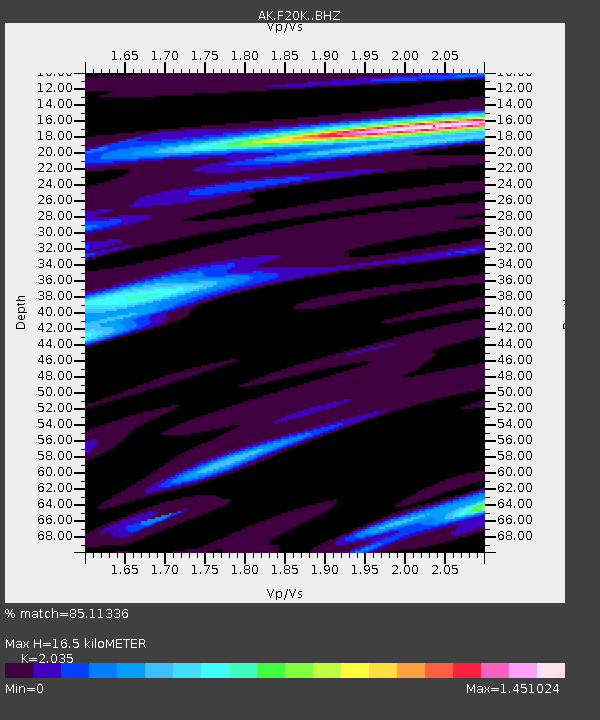
| Estimated Moho Depth: |
16.5 km |
| Estimated Crust Vp/Vs: |
2.04 |
| Assumed Crust Vp: |
6.522 km/s |
| Estimated Crust Vs: |
3.205 km/s |
| Estimated Crust Poisson's Ratio: |
0.34 |
|
| Radial Match: |
85.11336 % |
| Radial Bump: |
387 |
| Transverse Match: |
69.66811 % |
| Transverse Bump: |
400 |
| SOD ConfigId: |
33437571 |
| Insert Time: |
2024-01-11 09:22:16.165 +0000 |
| GWidth: |
2.5 |
| Max Bumps: |
400 |
| Tol: |
0.001 |
|

Signal To Noise
| Channel | StoN | STA | LTA |
| AK:F20K: :BHZ:20231228T09:21:48.679987Z | 1.0569932 | 9.369949E-7 | 8.86472E-7 |
| AK:F20K: :BHN:20231228T09:21:48.679987Z | 0.6523661 | 5.386264E-7 | 8.256505E-7 |
| AK:F20K: :BHE:20231228T09:21:48.679987Z | 1.617423 | 1.0343788E-6 | 6.3952274E-7 |
| Arrivals |
| Ps | 2.8 SECOND |
| PpPs | 7.2 SECOND |
| PsPs/PpSs | 10.0 SECOND |


