You are here: Home > Network List > AU - Australian Seismological Centre Stations List
> Station KIM05 GSWA station > Earthquake Result Viewer
KIM05 GSWA station - Earthquake Result Viewer
| Earthquake location: |
Kuril Islands |
| Earthquake latitude/longitude: |
44.6/149.0 |
| Earthquake time(UTC): |
2023/12/28 (362) 09:15:15 GMT |
| Earthquake Depth: |
24 km |
| Earthquake Magnitude: |
6.5 Mww |
| Earthquake Catalog/Contributor: |
NEIC PDE/us |
|
| Network: |
AU Australian Seismological Centre |
| Station: |
KIM05 GSWA station |
| Lat/Lon: |
17.99 S/124.19 E |
| Elevation: |
70 m |
|
| Distance: |
66.3 deg |
| Az: |
205.857 deg |
| Baz: |
19.116 deg |
| Ray Param: |
0.057708204 |
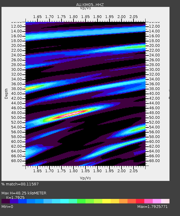
| Estimated Moho Depth: |
48.25 km |
| Estimated Crust Vp/Vs: |
1.79 |
| Assumed Crust Vp: |
6.496 km/s |
| Estimated Crust Vs: |
3.624 km/s |
| Estimated Crust Poisson's Ratio: |
0.27 |
|
| Radial Match: |
88.11597 % |
| Radial Bump: |
400 |
| Transverse Match: |
73.34521 % |
| Transverse Bump: |
400 |
| SOD ConfigId: |
33437571 |
| Insert Time: |
2024-01-11 09:24:24.943 +0000 |
| GWidth: |
2.5 |
| Max Bumps: |
400 |
| Tol: |
0.001 |
|

Signal To Noise
| Channel | StoN | STA | LTA |
| AU:KIM05: :HHZ:20231228T09:25:30.380Z | 4.8865547 | 1.2260502E-6 | 2.509028E-7 |
| AU:KIM05: :HHN:20231228T09:25:30.380Z | 2.2942684 | 6.15029E-7 | 2.6807194E-7 |
| AU:KIM05: :HHE:20231228T09:25:30.380Z | 1.9637153 | 3.847542E-7 | 1.9593176E-7 |
| Arrivals |
| Ps | 6.1 SECOND |
| PpPs | 20 SECOND |
| PsPs/PpSs | 26 SECOND |


