You are here: Home > Network List > AV - Alaska Volcano Observatory Stations List
> Station SPBL Spurr Beluga Lake, Mount Spur, Alaska > Earthquake Result Viewer
SPBL Spurr Beluga Lake, Mount Spur, Alaska - Earthquake Result Viewer
| Earthquake location: |
Kuril Islands |
| Earthquake latitude/longitude: |
44.6/149.0 |
| Earthquake time(UTC): |
2023/12/28 (362) 09:15:15 GMT |
| Earthquake Depth: |
24 km |
| Earthquake Magnitude: |
6.5 Mww |
| Earthquake Catalog/Contributor: |
NEIC PDE/us |
|
| Network: |
AV Alaska Volcano Observatory |
| Station: |
SPBL Spurr Beluga Lake, Mount Spur, Alaska |
| Lat/Lon: |
61.38 N/151.89 W |
| Elevation: |
927 m |
|
| Distance: |
37.8 deg |
| Az: |
42.347 deg |
| Baz: |
271.432 deg |
| Ray Param: |
0.07587214 |
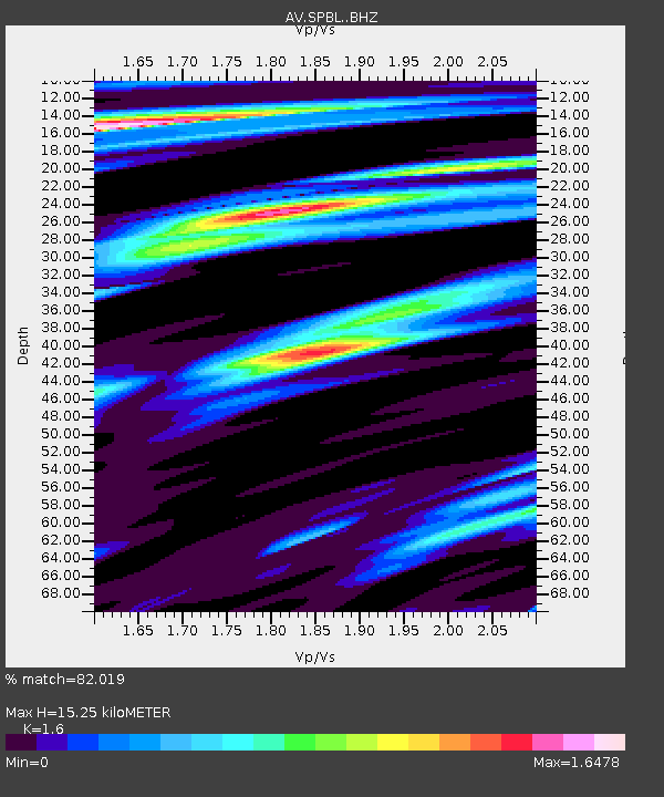
| Estimated Moho Depth: |
15.25 km |
| Estimated Crust Vp/Vs: |
1.60 |
| Assumed Crust Vp: |
6.302 km/s |
| Estimated Crust Vs: |
3.938 km/s |
| Estimated Crust Poisson's Ratio: |
0.18 |
|
| Radial Match: |
82.019 % |
| Radial Bump: |
400 |
| Transverse Match: |
55.465527 % |
| Transverse Bump: |
302 |
| SOD ConfigId: |
33437571 |
| Insert Time: |
2024-01-11 09:26:01.384 +0000 |
| GWidth: |
2.5 |
| Max Bumps: |
400 |
| Tol: |
0.001 |
|

Signal To Noise
| Channel | StoN | STA | LTA |
| AV:SPBL: :BHZ:20231228T09:21:59.420008Z | 7.2815814 | 2.4513215E-6 | 3.3664688E-7 |
| AV:SPBL: :BHN:20231228T09:21:59.420008Z | 0.8489103 | 1.4092097E-6 | 1.660022E-6 |
| AV:SPBL: :BHE:20231228T09:21:59.420008Z | 1.0514072 | 1.4199467E-6 | 1.3505202E-6 |
| Arrivals |
| Ps | 1.6 SECOND |
| PpPs | 5.8 SECOND |
| PsPs/PpSs | 7.4 SECOND |


