You are here: Home > Network List > CI - Caltech Regional Seismic Network Stations List
> Station MPP McPhearson Peak > Earthquake Result Viewer
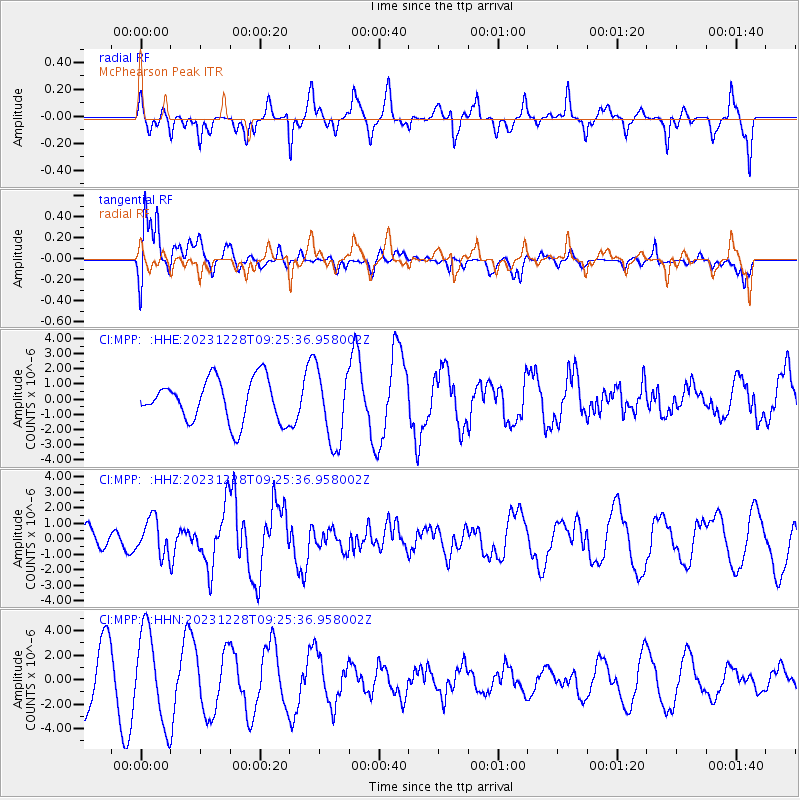
MPP McPhearson Peak - Earthquake Result Viewer
*The percent match for this event was below the threshold and hence no stack was calculated.
| Earthquake location: |
Kuril Islands |
| Earthquake latitude/longitude: |
44.6/149.0 |
| Earthquake time(UTC): |
2023/12/28 (362) 09:15:15 GMT |
| Earthquake Depth: |
24 km |
| Earthquake Magnitude: |
6.5 Mww |
| Earthquake Catalog/Contributor: |
NEIC PDE/us |
|
| Network: |
CI Caltech Regional Seismic Network |
| Station: |
MPP McPhearson Peak |
| Lat/Lon: |
34.89 N/119.81 W |
| Elevation: |
1739 m |
|
| Distance: |
67.3 deg |
| Az: |
62.992 deg |
| Baz: |
309.239 deg |
| Ray Param: |
$rayparam |
*The percent match for this event was below the threshold and hence was not used in the summary stack. |
|
| Radial Match: |
61.625324 % |
| Radial Bump: |
337 |
| Transverse Match: |
48.918854 % |
| Transverse Bump: |
381 |
| SOD ConfigId: |
33437571 |
| Insert Time: |
2024-01-11 09:29:35.347 +0000 |
| GWidth: |
2.5 |
| Max Bumps: |
400 |
| Tol: |
0.001 |
|
Signal To Noise
| Channel | StoN | STA | LTA |
| CI:MPP: :HHZ:20231228T09:25:36.958002Z | 0.9942542 | 1.1615667E-6 | 1.1682795E-6 |
| CI:MPP: :HHN:20231228T09:25:36.958002Z | 1.7270876 | 3.7420011E-6 | 2.166654E-6 |
| CI:MPP: :HHE:20231228T09:25:36.958002Z | 1.7479241 | 2.4422268E-6 | 1.3972157E-6 |
| Arrivals |
| Ps | |
| PpPs | |
| PsPs/PpSs | |


