You are here: Home > Network List > CN - Canadian National Seismograph Network Stations List
> Station INK INUVIK, NT > Earthquake Result Viewer
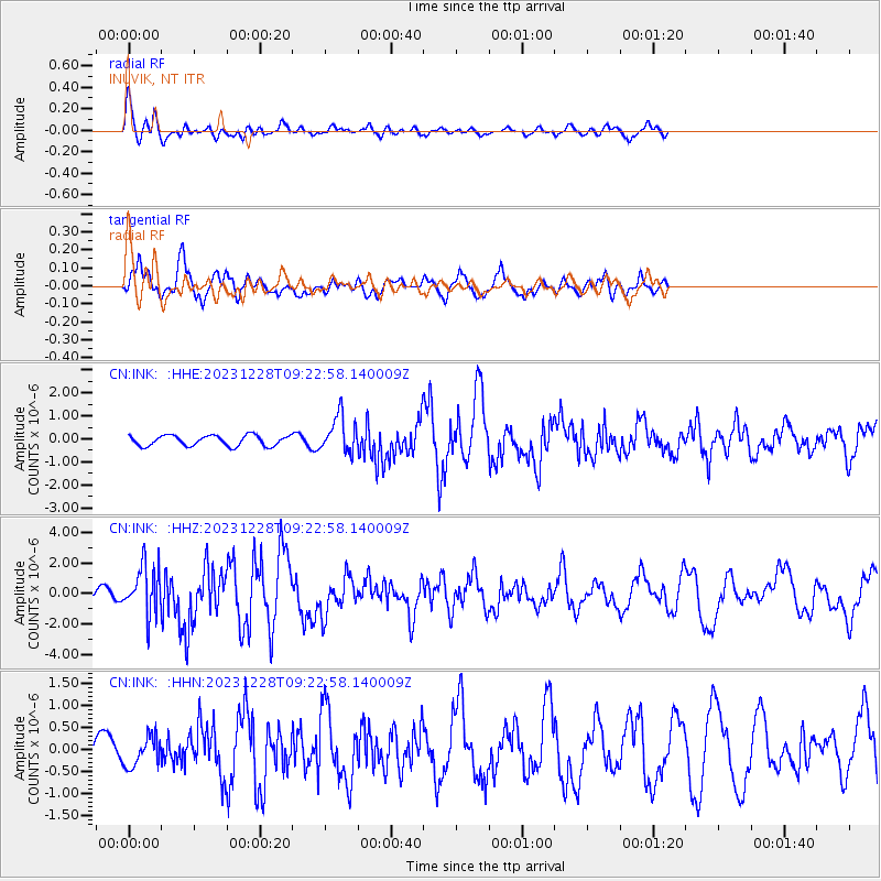
INK INUVIK, NT - Earthquake Result Viewer
*The percent match for this event was below the threshold and hence no stack was calculated.
| Earthquake location: |
Kuril Islands |
| Earthquake latitude/longitude: |
44.6/149.0 |
| Earthquake time(UTC): |
2023/12/28 (362) 09:15:15 GMT |
| Earthquake Depth: |
24 km |
| Earthquake Magnitude: |
6.5 Mww |
| Earthquake Catalog/Contributor: |
NEIC PDE/us |
|
| Network: |
CN Canadian National Seismograph Network |
| Station: |
INK INUVIK, NT |
| Lat/Lon: |
68.31 N/133.53 W |
| Elevation: |
44 m |
|
| Distance: |
45.0 deg |
| Az: |
30.875 deg |
| Baz: |
279.465 deg |
| Ray Param: |
$rayparam |
*The percent match for this event was below the threshold and hence was not used in the summary stack. |
|
| Radial Match: |
72.109856 % |
| Radial Bump: |
400 |
| Transverse Match: |
82.1076 % |
| Transverse Bump: |
400 |
| SOD ConfigId: |
33437571 |
| Insert Time: |
2024-01-11 09:31:13.776 +0000 |
| GWidth: |
2.5 |
| Max Bumps: |
400 |
| Tol: |
0.001 |
|
Signal To Noise
| Channel | StoN | STA | LTA |
| CN:INK: :HHZ:20231228T09:22:58.140009Z | 4.5846257 | 1.5856098E-6 | 3.4585372E-7 |
| CN:INK: :HHN:20231228T09:22:58.140009Z | 0.5043389 | 3.3514465E-7 | 6.645227E-7 |
| CN:INK: :HHE:20231228T09:22:58.140009Z | 3.4730937 | 7.933916E-7 | 2.2843945E-7 |
| Arrivals |
| Ps | |
| PpPs | |
| PsPs/PpSs | |


