You are here: Home > Network List > US - United States National Seismic Network Stations List
> Station EGMT Eagleton, Montana, USA > Earthquake Result Viewer
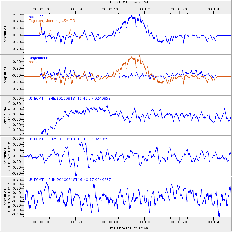
EGMT Eagleton, Montana, USA - Earthquake Result Viewer
*The percent match for this event was below the threshold and hence no stack was calculated.
| Earthquake location: |
South Of Mariana Islands |
| Earthquake latitude/longitude: |
12.2/141.5 |
| Earthquake time(UTC): |
2010/08/18 (230) 16:28:15 GMT |
| Earthquake Depth: |
10 km |
| Earthquake Magnitude: |
5.8 MB, 5.9 MS, 6.3 MW, 6.2 MW |
| Earthquake Catalog/Contributor: |
WHDF/NEIC |
|
| Network: |
US United States National Seismic Network |
| Station: |
EGMT Eagleton, Montana, USA |
| Lat/Lon: |
48.02 N/109.75 W |
| Elevation: |
1055 m |
|
| Distance: |
93.1 deg |
| Az: |
39.546 deg |
| Baz: |
291.999 deg |
| Ray Param: |
$rayparam |
*The percent match for this event was below the threshold and hence was not used in the summary stack. |
|
| Radial Match: |
26.105509 % |
| Radial Bump: |
400 |
| Transverse Match: |
37.572094 % |
| Transverse Bump: |
400 |
| SOD ConfigId: |
319893 |
| Insert Time: |
2011-01-06 00:58:33.680 +0000 |
| GWidth: |
2.5 |
| Max Bumps: |
400 |
| Tol: |
0.001 |
|
Signal To Noise
| Channel | StoN | STA | LTA |
| US:EGMT: :BHZ:20100818T16:40:57.924985Z | 2.0335243 | 1.454283E-7 | 7.15154E-8 |
| US:EGMT: :BHN:20100818T16:40:57.924985Z | 0.7018684 | 1.4947526E-7 | 2.1296763E-7 |
| US:EGMT: :BHE:20100818T16:40:57.924985Z | 1.3584112 | 6.2713434E-7 | 4.6166753E-7 |
| Arrivals |
| Ps | |
| PpPs | |
| PsPs/PpSs | |


