You are here: Home > Network List > CI - Caltech Regional Seismic Network Stations List
> Station GLA Glamis, Glamis, CA, USA > Earthquake Result Viewer
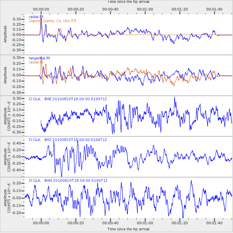
GLA Glamis, Glamis, CA, USA - Earthquake Result Viewer
*The percent match for this event was below the threshold and hence no stack was calculated.
| Earthquake location: |
Solomon Islands |
| Earthquake latitude/longitude: |
-6.6/154.2 |
| Earthquake time(UTC): |
2010/08/20 (232) 17:56:14 GMT |
| Earthquake Depth: |
19 km |
| Earthquake Magnitude: |
5.5 MB, 6.1 MS, 6.1 MW, 6.0 MW |
| Earthquake Catalog/Contributor: |
WHDF/NEIC |
|
| Network: |
CI Caltech Regional Seismic Network |
| Station: |
GLA Glamis, Glamis, CA, USA |
| Lat/Lon: |
33.05 N/114.83 W |
| Elevation: |
610 m |
|
| Distance: |
94.3 deg |
| Az: |
57.365 deg |
| Baz: |
265.01 deg |
| Ray Param: |
$rayparam |
*The percent match for this event was below the threshold and hence was not used in the summary stack. |
|
| Radial Match: |
49.7238 % |
| Radial Bump: |
400 |
| Transverse Match: |
46.27561 % |
| Transverse Bump: |
400 |
| SOD ConfigId: |
319893 |
| Insert Time: |
2011-01-06 01:02:32.687 +0000 |
| GWidth: |
2.5 |
| Max Bumps: |
400 |
| Tol: |
0.001 |
|
Signal To Noise
| Channel | StoN | STA | LTA |
| CI:GLA: :BHZ:20100820T18:09:00.619971Z | 2.3575304 | 1.4339426E-7 | 6.082393E-8 |
| CI:GLA: :BHN:20100820T18:09:00.619971Z | 1.553384 | 9.264782E-8 | 5.964257E-8 |
| CI:GLA: :BHE:20100820T18:09:00.619971Z | 0.93739265 | 8.566834E-8 | 9.139002E-8 |
| Arrivals |
| Ps | |
| PpPs | |
| PsPs/PpSs | |


