You are here: Home > Network List > KN - Kyrgyz Seismic Telemetry Network Stations List
> Station KZA KN.KZA > Earthquake Result Viewer
KZA KN.KZA - Earthquake Result Viewer

| Earthquake location: |
Solomon Islands |
| Earthquake latitude/longitude: |
-6.6/154.2 |
| Earthquake time(UTC): |
2010/08/20 (232) 17:56:14 GMT |
| Earthquake Depth: |
19 km |
| Earthquake Magnitude: |
5.5 MB, 6.1 MS, 6.1 MW, 6.0 MW |
| Earthquake Catalog/Contributor: |
WHDF/NEIC |
|
| Network: |
KN Kyrgyz Seismic Telemetry Network |
| Station: |
KZA KN.KZA |
| Lat/Lon: |
42.08 N/75.25 E |
| Elevation: |
3520 m |
|
| Distance: |
86.3 deg |
| Az: |
312.917 deg |
| Baz: |
102.221 deg |
| Ray Param: |
0.044165518 |
| Estimated Moho Depth: |
19.25 km |
| Estimated Crust Vp/Vs: |
1.60 |
| Assumed Crust Vp: |
6.306 km/s |
| Estimated Crust Vs: |
3.941 km/s |
| Estimated Crust Poisson's Ratio: |
0.18 |
|
| Radial Match: |
93.986565 % |
| Radial Bump: |
400 |
| Transverse Match: |
92.72177 % |
| Transverse Bump: |
400 |
| SOD ConfigId: |
319893 |
| Insert Time: |
2011-01-06 01:04:37.370 +0000 |
| GWidth: |
2.5 |
| Max Bumps: |
400 |
| Tol: |
0.001 |
|
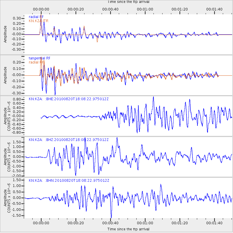
Signal To Noise
| Channel | StoN | STA | LTA |
| KN:KZA: :BHZ:20100820T18:08:22.975012Z | 6.467199 | 2.8397716E-7 | 4.3910383E-8 |
| KN:KZA: :BHN:20100820T18:08:22.975012Z | 1.5886861 | 5.6974038E-8 | 3.5862364E-8 |
| KN:KZA: :BHE:20100820T18:08:22.975012Z | 1.4832749 | 5.1334386E-8 | 3.4608814E-8 |
| Arrivals |
| Ps | 1.9 SECOND |
| PpPs | 7.7 SECOND |
| PsPs/PpSs | 9.6 SECOND |


