You are here: Home > Network List > US - United States National Seismic Network Stations List
> Station EGMT Eagleton, Montana, USA > Earthquake Result Viewer
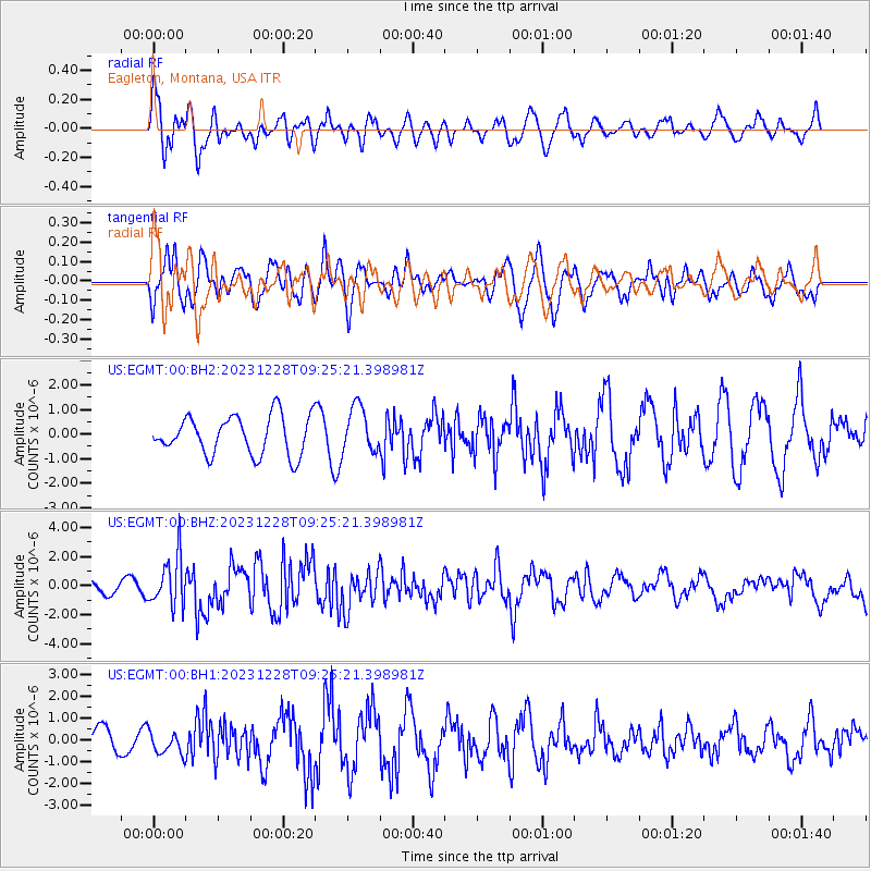
EGMT Eagleton, Montana, USA - Earthquake Result Viewer
*The percent match for this event was below the threshold and hence no stack was calculated.
| Earthquake location: |
Kuril Islands |
| Earthquake latitude/longitude: |
44.6/149.0 |
| Earthquake time(UTC): |
2023/12/28 (362) 09:15:15 GMT |
| Earthquake Depth: |
24 km |
| Earthquake Magnitude: |
6.5 Mww |
| Earthquake Catalog/Contributor: |
NEIC PDE/us |
|
| Network: |
US United States National Seismic Network |
| Station: |
EGMT Eagleton, Montana, USA |
| Lat/Lon: |
48.02 N/109.75 W |
| Elevation: |
1055 m |
|
| Distance: |
64.9 deg |
| Az: |
46.659 deg |
| Baz: |
309.265 deg |
| Ray Param: |
$rayparam |
*The percent match for this event was below the threshold and hence was not used in the summary stack. |
|
| Radial Match: |
58.13191 % |
| Radial Bump: |
400 |
| Transverse Match: |
49.801647 % |
| Transverse Bump: |
400 |
| SOD ConfigId: |
33437571 |
| Insert Time: |
2024-01-11 09:50:00.547 +0000 |
| GWidth: |
2.5 |
| Max Bumps: |
400 |
| Tol: |
0.001 |
|
Signal To Noise
| Channel | StoN | STA | LTA |
| US:EGMT:00:BHZ:20231228T09:25:21.398981Z | 4.0222044 | 1.6889326E-6 | 4.1990222E-7 |
| US:EGMT:00:BH1:20231228T09:25:21.398981Z | 0.957339 | 5.2276073E-7 | 5.46056E-7 |
| US:EGMT:00:BH2:20231228T09:25:21.398981Z | 1.1892798 | 9.325396E-7 | 7.841213E-7 |
| Arrivals |
| Ps | |
| PpPs | |
| PsPs/PpSs | |


